You are here: Home > Network List > WY - Yellowstone Wyoming Seismic Network Stations List
> Station YHR Hawk's Rest, WY, USA > Earthquake Result Viewer
YHR Hawk's Rest, WY, USA - Earthquake Result Viewer
| Earthquake location: |
Southern Bolivia |
| Earthquake latitude/longitude: |
-19.8/-63.3 |
| Earthquake time(UTC): |
2016/01/14 (014) 03:25:28 GMT |
| Earthquake Depth: |
582 km |
| Earthquake Magnitude: |
6.1 MWW, 6.1 MWB |
| Earthquake Catalog/Contributor: |
NEIC PDE/NEIC COMCAT |
|
| Network: |
WY Yellowstone Wyoming Seismic Network |
| Station: |
YHR Hawk's Rest, WY, USA |
| Lat/Lon: |
44.11 N/110.08 W |
| Elevation: |
2976 m |
|
| Distance: |
76.7 deg |
| Az: |
327.341 deg |
| Baz: |
135.152 deg |
| Ray Param: |
0.04898058 |
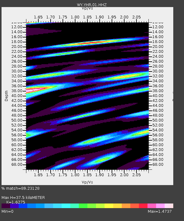
| Estimated Moho Depth: |
37.5 km |
| Estimated Crust Vp/Vs: |
1.63 |
| Assumed Crust Vp: |
6.35 km/s |
| Estimated Crust Vs: |
3.902 km/s |
| Estimated Crust Poisson's Ratio: |
0.20 |
|
| Radial Match: |
89.23128 % |
| Radial Bump: |
400 |
| Transverse Match: |
80.085495 % |
| Transverse Bump: |
400 |
| SOD ConfigId: |
1399611 |
| Insert Time: |
2016-01-28 04:17:17.701 +0000 |
| GWidth: |
2.5 |
| Max Bumps: |
400 |
| Tol: |
0.001 |
|
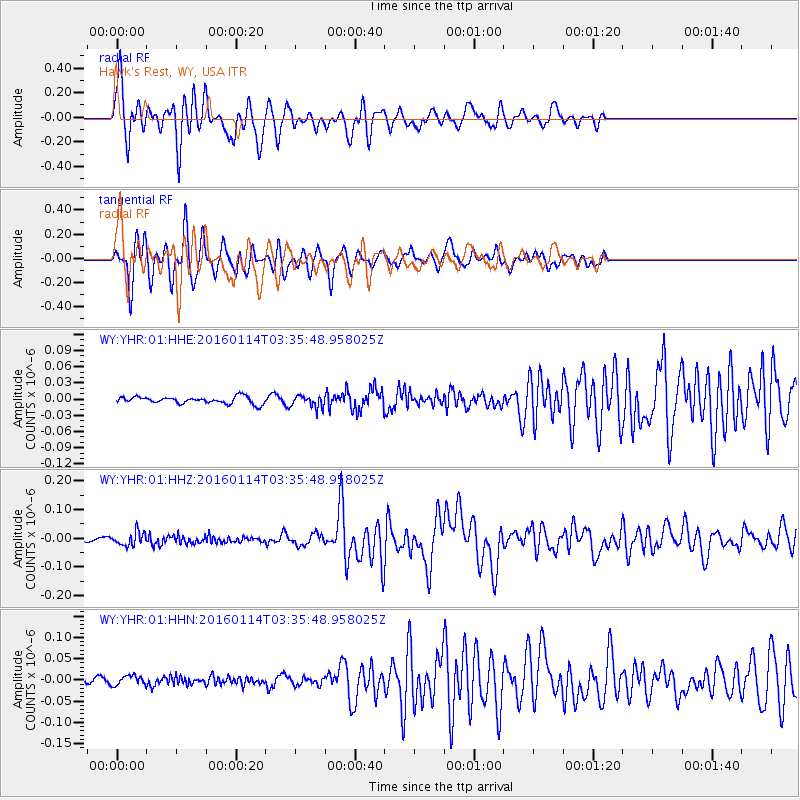
Signal To Noise
| Channel | StoN | STA | LTA |
| WY:YHR:01:HHZ:20160114T03:35:48.958025Z | 5.4283834 | 2.3477693E-8 | 4.3249884E-9 |
| WY:YHR:01:HHN:20160114T03:35:48.958025Z | 1.4501705 | 1.1905026E-8 | 8.209398E-9 |
| WY:YHR:01:HHE:20160114T03:35:48.958025Z | 1.7561849 | 1.1214997E-8 | 6.386E-9 |
| Arrivals |
| Ps | 3.8 SECOND |
| PpPs | 15 SECOND |
| PsPs/PpSs | 19 SECOND |


