You are here: Home > Network List > AV - Alaska Volcano Observatory Stations List
> Station AMKA Regional Station, Amchitka Island, Alaska > Earthquake Result Viewer
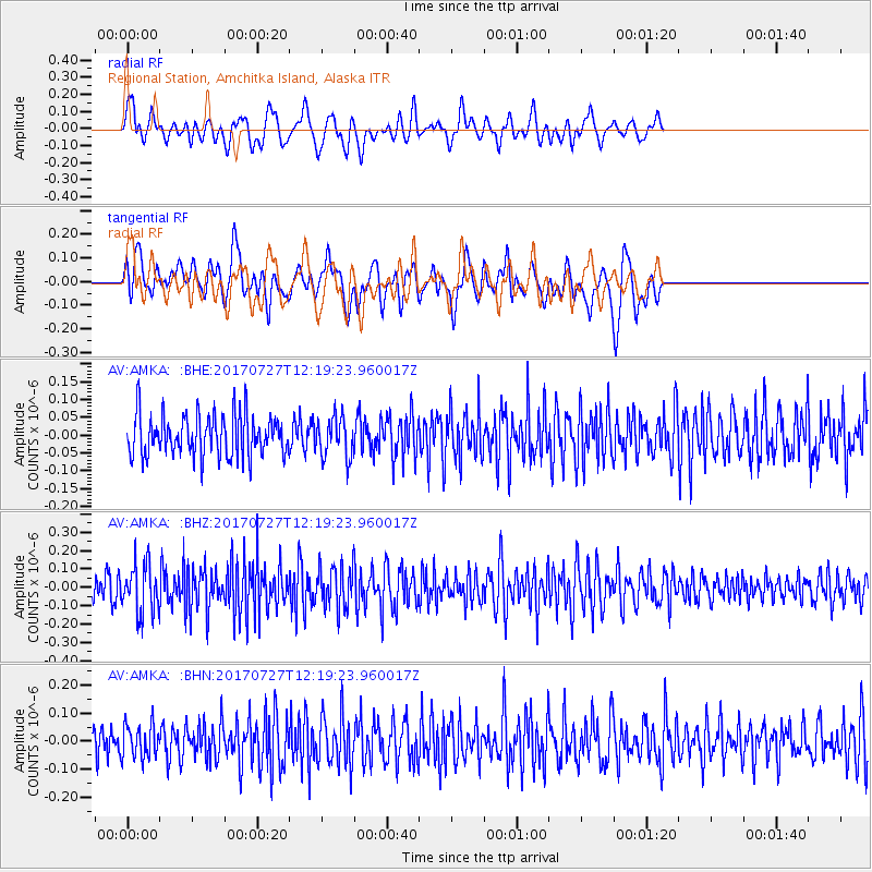
AMKA Regional Station, Amchitka Island, Alaska - Earthquake Result Viewer
*The percent match for this event was below the threshold and hence no stack was calculated.
| Earthquake location: |
Buru, Indonesia |
| Earthquake latitude/longitude: |
-3.5/126.1 |
| Earthquake time(UTC): |
2017/07/27 (208) 12:08:38 GMT |
| Earthquake Depth: |
15 km |
| Earthquake Magnitude: |
5.8 Mww |
| Earthquake Catalog/Contributor: |
NEIC PDE/us |
|
| Network: |
AV Alaska Volcano Observatory |
| Station: |
AMKA Regional Station, Amchitka Island, Alaska |
| Lat/Lon: |
51.38 N/179.30 E |
| Elevation: |
116 m |
|
| Distance: |
70.9 deg |
| Az: |
32.086 deg |
| Baz: |
237.775 deg |
| Ray Param: |
$rayparam |
*The percent match for this event was below the threshold and hence was not used in the summary stack. |
|
| Radial Match: |
51.578423 % |
| Radial Bump: |
400 |
| Transverse Match: |
57.162277 % |
| Transverse Bump: |
400 |
| SOD ConfigId: |
13570011 |
| Insert Time: |
2019-04-28 11:31:23.203 +0000 |
| GWidth: |
2.5 |
| Max Bumps: |
400 |
| Tol: |
0.001 |
|
Signal To Noise
| Channel | StoN | STA | LTA |
| AV:AMKA: :BHZ:20170727T12:19:23.960017Z | 2.0252388 | 1.2996831E-7 | 6.417432E-8 |
| AV:AMKA: :BHN:20170727T12:19:23.960017Z | 1.0176929 | 6.024508E-8 | 5.91977E-8 |
| AV:AMKA: :BHE:20170727T12:19:23.960017Z | 0.9820567 | 5.607809E-8 | 5.7102703E-8 |
| Arrivals |
| Ps | |
| PpPs | |
| PsPs/PpSs | |


