You are here: Home > Network List > TA - USArray Transportable Network (new EarthScope stations) Stations List
> Station J25A Sunshine Ranch, Edgemont, SD, USA > Earthquake Result Viewer
J25A Sunshine Ranch, Edgemont, SD, USA - Earthquake Result Viewer
| Earthquake location: |
Samoa Islands Region |
| Earthquake latitude/longitude: |
-15.2/-172.6 |
| Earthquake time(UTC): |
2009/08/30 (242) 14:51:32 GMT |
| Earthquake Depth: |
11 km |
| Earthquake Magnitude: |
6.4 MB, 6.3 MS, 6.6 MW, 6.6 MW |
| Earthquake Catalog/Contributor: |
WHDF/NEIC |
|
| Network: |
TA USArray Transportable Network (new EarthScope stations) |
| Station: |
J25A Sunshine Ranch, Edgemont, SD, USA |
| Lat/Lon: |
43.39 N/103.80 W |
| Elevation: |
1220 m |
|
| Distance: |
85.6 deg |
| Az: |
42.961 deg |
| Baz: |
244.483 deg |
| Ray Param: |
0.044626333 |
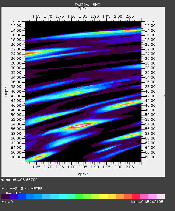
| Estimated Moho Depth: |
54.5 km |
| Estimated Crust Vp/Vs: |
1.84 |
| Assumed Crust Vp: |
6.483 km/s |
| Estimated Crust Vs: |
3.533 km/s |
| Estimated Crust Poisson's Ratio: |
0.29 |
|
| Radial Match: |
95.65709 % |
| Radial Bump: |
400 |
| Transverse Match: |
86.31138 % |
| Transverse Bump: |
400 |
| SOD ConfigId: |
2622 |
| Insert Time: |
2010-03-06 02:18:26.627 +0000 |
| GWidth: |
2.5 |
| Max Bumps: |
400 |
| Tol: |
0.001 |
|
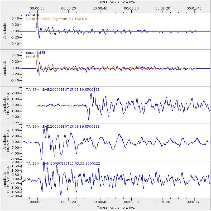
Signal To Noise
| Channel | StoN | STA | LTA |
| TA:J25A: :BHZ:20090830T15:03:39.850022Z | 20.834211 | 2.9378532E-6 | 1.41011E-7 |
| TA:J25A: :BHN:20090830T15:03:39.850022Z | 7.0735183 | 8.9271185E-7 | 1.262048E-7 |
| TA:J25A: :BHE:20090830T15:03:39.850022Z | 12.5082655 | 1.1975785E-6 | 9.574297E-8 |
| Arrivals |
| Ps | 7.2 SECOND |
| PpPs | 23 SECOND |
| PsPs/PpSs | 30 SECOND |


