You are here: Home > Network List > TA - USArray Transportable Network (new EarthScope stations) Stations List
> Station J25A Sunshine Ranch, Edgemont, SD, USA > Earthquake Result Viewer
J25A Sunshine Ranch, Edgemont, SD, USA - Earthquake Result Viewer
| Earthquake location: |
Samoa Islands Region |
| Earthquake latitude/longitude: |
-15.5/-172.1 |
| Earthquake time(UTC): |
2009/09/29 (272) 17:48:10 GMT |
| Earthquake Depth: |
18 km |
| Earthquake Magnitude: |
7.1 MB, 8.1 MS, 8.1 MW, 8.0 MW |
| Earthquake Catalog/Contributor: |
WHDF/NEIC |
|
| Network: |
TA USArray Transportable Network (new EarthScope stations) |
| Station: |
J25A Sunshine Ranch, Edgemont, SD, USA |
| Lat/Lon: |
43.39 N/103.80 W |
| Elevation: |
1220 m |
|
| Distance: |
85.5 deg |
| Az: |
42.795 deg |
| Baz: |
243.965 deg |
| Ray Param: |
0.044699237 |
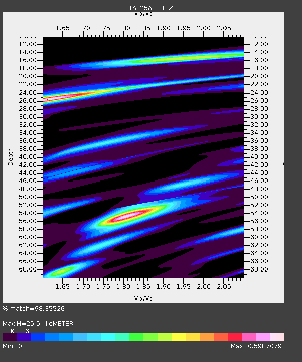
| Estimated Moho Depth: |
25.5 km |
| Estimated Crust Vp/Vs: |
1.61 |
| Assumed Crust Vp: |
6.483 km/s |
| Estimated Crust Vs: |
4.026 km/s |
| Estimated Crust Poisson's Ratio: |
0.19 |
|
| Radial Match: |
98.35526 % |
| Radial Bump: |
358 |
| Transverse Match: |
91.56229 % |
| Transverse Bump: |
400 |
| SOD ConfigId: |
2622 |
| Insert Time: |
2010-03-06 02:18:32.462 +0000 |
| GWidth: |
2.5 |
| Max Bumps: |
400 |
| Tol: |
0.001 |
|
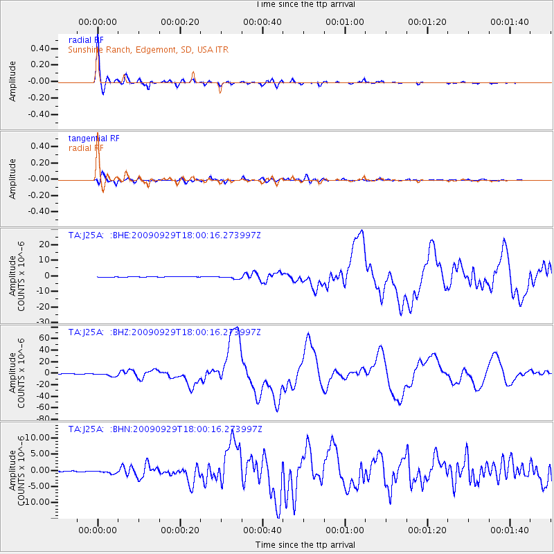
Signal To Noise
| Channel | StoN | STA | LTA |
| TA:J25A: :BHZ:20090929T18:00:16.273997Z | 13.440283 | 2.8074332E-6 | 2.08882E-7 |
| TA:J25A: :BHN:20090929T18:00:16.273997Z | 3.8519535 | 4.4018734E-7 | 1.1427638E-7 |
| TA:J25A: :BHE:20090929T18:00:16.273997Z | 7.015692 | 9.251172E-7 | 1.31864E-7 |
| Arrivals |
| Ps | 2.5 SECOND |
| PpPs | 10.0 SECOND |
| PsPs/PpSs | 12 SECOND |


