You are here: Home > Network List > TA - USArray Transportable Network (new EarthScope stations) Stations List
> Station R32K Eaglecrest, AK, USA > Earthquake Result Viewer
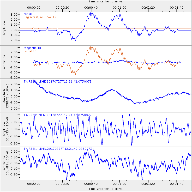
R32K Eaglecrest, AK, USA - Earthquake Result Viewer
*The percent match for this event was below the threshold and hence no stack was calculated.
| Earthquake location: |
Buru, Indonesia |
| Earthquake latitude/longitude: |
-3.5/126.1 |
| Earthquake time(UTC): |
2017/07/27 (208) 12:08:38 GMT |
| Earthquake Depth: |
15 km |
| Earthquake Magnitude: |
5.8 Mww |
| Earthquake Catalog/Contributor: |
NEIC PDE/us |
|
| Network: |
TA USArray Transportable Network (new EarthScope stations) |
| Station: |
R32K Eaglecrest, AK, USA |
| Lat/Lon: |
58.27 N/134.52 W |
| Elevation: |
386 m |
|
| Distance: |
98.0 deg |
| Az: |
31.759 deg |
| Baz: |
276.154 deg |
| Ray Param: |
$rayparam |
*The percent match for this event was below the threshold and hence was not used in the summary stack. |
|
| Radial Match: |
17.013136 % |
| Radial Bump: |
400 |
| Transverse Match: |
43.08269 % |
| Transverse Bump: |
400 |
| SOD ConfigId: |
13570011 |
| Insert Time: |
2019-04-28 11:33:12.175 +0000 |
| GWidth: |
2.5 |
| Max Bumps: |
400 |
| Tol: |
0.001 |
|
Signal To Noise
| Channel | StoN | STA | LTA |
| TA:R32K: :BHZ:20170727T12:21:42.075007Z | 0.9613052 | 8.276323E-8 | 8.6094644E-8 |
| TA:R32K: :BHN:20170727T12:21:42.075007Z | 1.1521118 | 2.0793891E-7 | 1.8048502E-7 |
| TA:R32K: :BHE:20170727T12:21:42.075007Z | 1.5044619 | 1.22327E-6 | 8.1309474E-7 |
| Arrivals |
| Ps | |
| PpPs | |
| PsPs/PpSs | |


