You are here: Home > Network List > 5H - Central Virginia and South Carolina seismic monitoring experiment Stations List
> Station ANNI Yanceyville, VA > Earthquake Result Viewer
ANNI Yanceyville, VA - Earthquake Result Viewer
| Earthquake location: |
North Atlantic Ocean |
| Earthquake latitude/longitude: |
13.4/-49.4 |
| Earthquake time(UTC): |
2017/07/27 (208) 17:53:25 GMT |
| Earthquake Depth: |
10 km |
| Earthquake Magnitude: |
5.9 Mww |
| Earthquake Catalog/Contributor: |
NEIC PDE/us |
|
| Network: |
5H Central Virginia and South Carolina seismic monitoring experiment |
| Station: |
ANNI Yanceyville, VA |
| Lat/Lon: |
37.94 N/77.97 W |
| Elevation: |
93 m |
|
| Distance: |
35.3 deg |
| Az: |
319.049 deg |
| Baz: |
126.228 deg |
| Ray Param: |
0.07731044 |
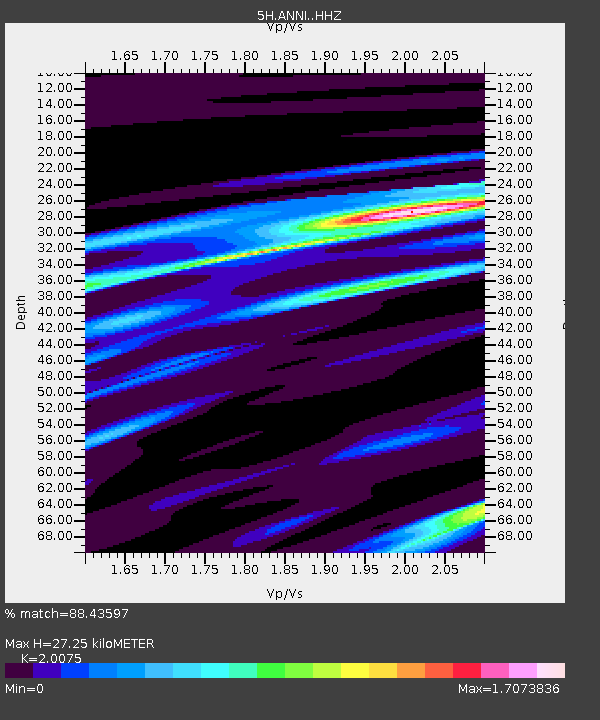
| Estimated Moho Depth: |
27.25 km |
| Estimated Crust Vp/Vs: |
2.01 |
| Assumed Crust Vp: |
6.565 km/s |
| Estimated Crust Vs: |
3.27 km/s |
| Estimated Crust Poisson's Ratio: |
0.33 |
|
| Radial Match: |
88.43597 % |
| Radial Bump: |
235 |
| Transverse Match: |
69.09017 % |
| Transverse Bump: |
400 |
| SOD ConfigId: |
13570011 |
| Insert Time: |
2019-04-28 11:33:43.713 +0000 |
| GWidth: |
2.5 |
| Max Bumps: |
400 |
| Tol: |
0.001 |
|

Signal To Noise
| Channel | StoN | STA | LTA |
| 5H:ANNI: :HHZ:20170727T17:59:48.774985Z | 4.5083165 | 3.354986E-7 | 7.441772E-8 |
| 5H:ANNI: :HHN:20170727T17:59:48.774985Z | 2.9274461 | 1.493933E-7 | 5.1031957E-8 |
| 5H:ANNI: :HHE:20170727T17:59:48.774985Z | 2.3782454 | 1.3992008E-7 | 5.883332E-8 |
| Arrivals |
| Ps | 4.5 SECOND |
| PpPs | 12 SECOND |
| PsPs/PpSs | 16 SECOND |


