You are here: Home > Network List > 5H - Central Virginia and South Carolina seismic monitoring experiment Stations List
> Station METL Louisa, VA > Earthquake Result Viewer
METL Louisa, VA - Earthquake Result Viewer
| Earthquake location: |
North Atlantic Ocean |
| Earthquake latitude/longitude: |
13.4/-49.4 |
| Earthquake time(UTC): |
2017/07/27 (208) 17:53:25 GMT |
| Earthquake Depth: |
10 km |
| Earthquake Magnitude: |
5.9 Mww |
| Earthquake Catalog/Contributor: |
NEIC PDE/us |
|
| Network: |
5H Central Virginia and South Carolina seismic monitoring experiment |
| Station: |
METL Louisa, VA |
| Lat/Lon: |
37.89 N/77.97 W |
| Elevation: |
114 m |
|
| Distance: |
35.2 deg |
| Az: |
318.982 deg |
| Baz: |
126.17 deg |
| Ray Param: |
0.07732292 |
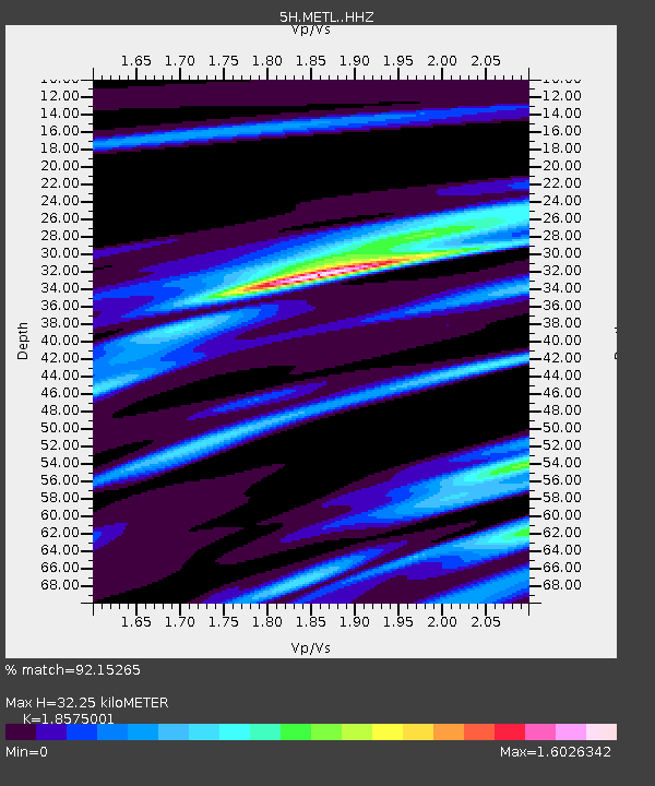
| Estimated Moho Depth: |
32.25 km |
| Estimated Crust Vp/Vs: |
1.86 |
| Assumed Crust Vp: |
6.565 km/s |
| Estimated Crust Vs: |
3.534 km/s |
| Estimated Crust Poisson's Ratio: |
0.30 |
|
| Radial Match: |
92.15265 % |
| Radial Bump: |
309 |
| Transverse Match: |
77.906296 % |
| Transverse Bump: |
400 |
| SOD ConfigId: |
13570011 |
| Insert Time: |
2019-04-28 11:33:52.230 +0000 |
| GWidth: |
2.5 |
| Max Bumps: |
400 |
| Tol: |
0.001 |
|

Signal To Noise
| Channel | StoN | STA | LTA |
| 5H:METL: :HHZ:20170727T17:59:48.575004Z | 4.515927 | 2.7202162E-7 | 6.0236054E-8 |
| 5H:METL: :HHN:20170727T17:59:48.575004Z | 2.8326285 | 1.657049E-7 | 5.849864E-8 |
| 5H:METL: :HHE:20170727T17:59:48.575004Z | 2.0765836 | 1.4843856E-7 | 7.1482106E-8 |
| Arrivals |
| Ps | 4.5 SECOND |
| PpPs | 13 SECOND |
| PsPs/PpSs | 18 SECOND |


