You are here: Home > Network List > 5H - Central Virginia and South Carolina seismic monitoring experiment Stations List
> Station PTTI Yanceyville, VA > Earthquake Result Viewer
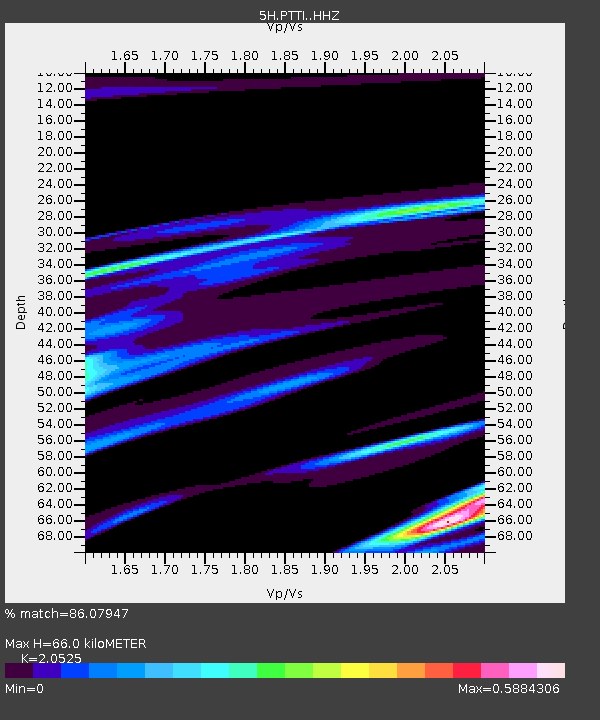
PTTI Yanceyville, VA - Earthquake Result Viewer
| Earthquake location: |
North Atlantic Ocean |
| Earthquake latitude/longitude: |
13.4/-49.4 |
| Earthquake time(UTC): |
2017/07/27 (208) 17:53:25 GMT |
| Earthquake Depth: |
10 km |
| Earthquake Magnitude: |
5.9 Mww |
| Earthquake Catalog/Contributor: |
NEIC PDE/us |
|
| Network: |
5H Central Virginia and South Carolina seismic monitoring experiment |
| Station: |
PTTI Yanceyville, VA |
| Lat/Lon: |
37.94 N/77.99 W |
| Elevation: |
98 m |
|
| Distance: |
35.3 deg |
| Az: |
319.04 deg |
| Baz: |
126.207 deg |
| Ray Param: |
0.07730197 |
| Estimated Moho Depth: |
66.0 km |
| Estimated Crust Vp/Vs: |
2.05 |
| Assumed Crust Vp: |
6.565 km/s |
| Estimated Crust Vs: |
3.198 km/s |
| Estimated Crust Poisson's Ratio: |
0.34 |
|
| Radial Match: |
86.07947 % |
| Radial Bump: |
400 |
| Transverse Match: |
52.06199 % |
| Transverse Bump: |
400 |
| SOD ConfigId: |
13570011 |
| Insert Time: |
2019-04-28 11:33:55.320 +0000 |
| GWidth: |
2.5 |
| Max Bumps: |
400 |
| Tol: |
0.001 |
|

Signal To Noise
| Channel | StoN | STA | LTA |
| 5H:PTTI: :HHZ:20170727T17:59:48.915Z | 4.3689523 | 3.3189235E-7 | 7.596612E-8 |
| 5H:PTTI: :HHN:20170727T17:59:48.915Z | 0.53578675 | 1.5607719E-7 | 2.913047E-7 |
| 5H:PTTI: :HHE:20170727T17:59:48.915Z | 0.8524979 | 1.7398602E-7 | 2.0408967E-7 |
| Arrivals |
| Ps | 11 SECOND |
| PpPs | 29 SECOND |
| PsPs/PpSs | 40 SECOND |


