You are here: Home > Network List > AK - Alaska Regional Network Stations List
> Station BCP Bancas Point, AK, USA > Earthquake Result Viewer
BCP Bancas Point, AK, USA - Earthquake Result Viewer
| Earthquake location: |
North Atlantic Ocean |
| Earthquake latitude/longitude: |
13.4/-49.4 |
| Earthquake time(UTC): |
2017/07/27 (208) 17:53:25 GMT |
| Earthquake Depth: |
10 km |
| Earthquake Magnitude: |
5.9 Mww |
| Earthquake Catalog/Contributor: |
NEIC PDE/us |
|
| Network: |
AK Alaska Regional Network |
| Station: |
BCP Bancas Point, AK, USA |
| Lat/Lon: |
59.95 N/139.63 W |
| Elevation: |
422 m |
|
| Distance: |
78.7 deg |
| Az: |
329.122 deg |
| Baz: |
82.992 deg |
| Ray Param: |
0.049483173 |
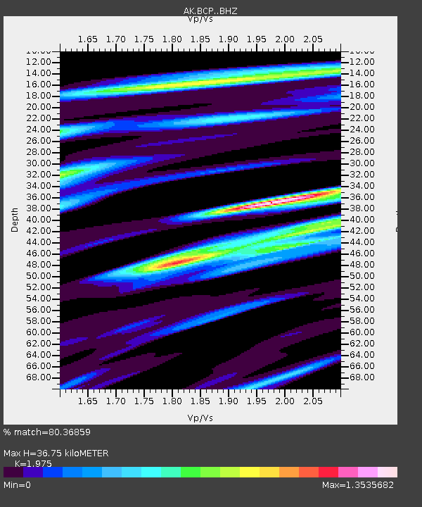
| Estimated Moho Depth: |
36.75 km |
| Estimated Crust Vp/Vs: |
1.98 |
| Assumed Crust Vp: |
6.183 km/s |
| Estimated Crust Vs: |
3.13 km/s |
| Estimated Crust Poisson's Ratio: |
0.33 |
|
| Radial Match: |
80.36859 % |
| Radial Bump: |
400 |
| Transverse Match: |
64.5262 % |
| Transverse Bump: |
400 |
| SOD ConfigId: |
13570011 |
| Insert Time: |
2019-04-28 11:34:10.216 +0000 |
| GWidth: |
2.5 |
| Max Bumps: |
400 |
| Tol: |
0.001 |
|

Signal To Noise
| Channel | StoN | STA | LTA |
| AK:BCP: :BHZ:20170727T18:04:55.467979Z | 2.3870945 | 2.1063872E-7 | 8.8240625E-8 |
| AK:BCP: :BHN:20170727T18:04:55.467979Z | 0.96662575 | 9.4784085E-8 | 9.805665E-8 |
| AK:BCP: :BHE:20170727T18:04:55.467979Z | 1.4534887 | 1.2378837E-7 | 8.516638E-8 |
| Arrivals |
| Ps | 5.9 SECOND |
| PpPs | 17 SECOND |
| PsPs/PpSs | 23 SECOND |


