You are here: Home > Network List > AK - Alaska Regional Network Stations List
> Station SSN Susitna > Earthquake Result Viewer
SSN Susitna - Earthquake Result Viewer
| Earthquake location: |
North Atlantic Ocean |
| Earthquake latitude/longitude: |
13.4/-49.4 |
| Earthquake time(UTC): |
2017/07/27 (208) 17:53:25 GMT |
| Earthquake Depth: |
10 km |
| Earthquake Magnitude: |
5.9 Mww |
| Earthquake Catalog/Contributor: |
NEIC PDE/us |
|
| Network: |
AK Alaska Regional Network |
| Station: |
SSN Susitna |
| Lat/Lon: |
61.46 N/150.74 W |
| Elevation: |
1293 m |
|
| Distance: |
83.7 deg |
| Az: |
331.731 deg |
| Baz: |
73.71 deg |
| Ray Param: |
0.04599343 |
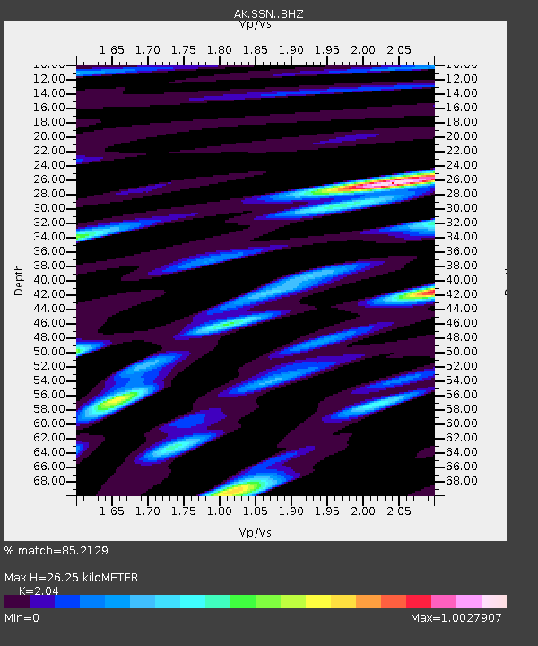
| Estimated Moho Depth: |
26.25 km |
| Estimated Crust Vp/Vs: |
2.04 |
| Assumed Crust Vp: |
6.302 km/s |
| Estimated Crust Vs: |
3.089 km/s |
| Estimated Crust Poisson's Ratio: |
0.34 |
|
| Radial Match: |
85.2129 % |
| Radial Bump: |
400 |
| Transverse Match: |
77.21786 % |
| Transverse Bump: |
400 |
| SOD ConfigId: |
13570011 |
| Insert Time: |
2019-04-28 11:34:56.684 +0000 |
| GWidth: |
2.5 |
| Max Bumps: |
400 |
| Tol: |
0.001 |
|

Signal To Noise
| Channel | StoN | STA | LTA |
| AK:SSN: :BHZ:20170727T18:05:22.128013Z | 6.2911944 | 4.424134E-7 | 7.032264E-8 |
| AK:SSN: :BHN:20170727T18:05:22.128013Z | 1.1463307 | 7.418947E-8 | 6.471908E-8 |
| AK:SSN: :BHE:20170727T18:05:22.128013Z | 1.7830667 | 1.4379293E-7 | 8.064361E-8 |
| Arrivals |
| Ps | 4.4 SECOND |
| PpPs | 12 SECOND |
| PsPs/PpSs | 17 SECOND |


