You are here: Home > Network List > AV - Alaska Volcano Observatory Stations List
> Station ILSW Iliamna Southwest, Iliamna Volcano, Alaska > Earthquake Result Viewer
ILSW Iliamna Southwest, Iliamna Volcano, Alaska - Earthquake Result Viewer
| Earthquake location: |
North Atlantic Ocean |
| Earthquake latitude/longitude: |
13.4/-49.4 |
| Earthquake time(UTC): |
2017/07/27 (208) 17:53:25 GMT |
| Earthquake Depth: |
10 km |
| Earthquake Magnitude: |
5.9 Mww |
| Earthquake Catalog/Contributor: |
NEIC PDE/us |
|
| Network: |
AV Alaska Volcano Observatory |
| Station: |
ILSW Iliamna Southwest, Iliamna Volcano, Alaska |
| Lat/Lon: |
59.98 N/153.14 W |
| Elevation: |
1318 m |
|
| Distance: |
85.3 deg |
| Az: |
330.661 deg |
| Baz: |
71.519 deg |
| Ray Param: |
0.0448776 |
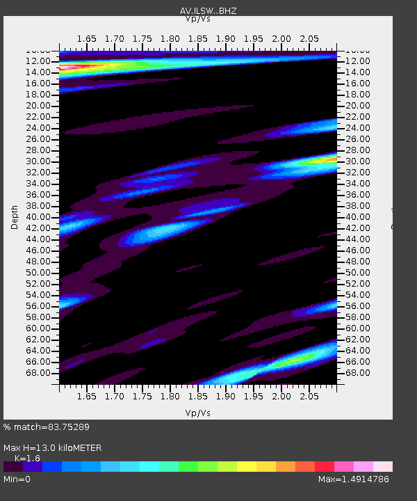
| Estimated Moho Depth: |
13.0 km |
| Estimated Crust Vp/Vs: |
1.60 |
| Assumed Crust Vp: |
5.989 km/s |
| Estimated Crust Vs: |
3.743 km/s |
| Estimated Crust Poisson's Ratio: |
0.18 |
|
| Radial Match: |
83.75289 % |
| Radial Bump: |
400 |
| Transverse Match: |
76.37093 % |
| Transverse Bump: |
400 |
| SOD ConfigId: |
13570011 |
| Insert Time: |
2019-04-28 11:35:15.626 +0000 |
| GWidth: |
2.5 |
| Max Bumps: |
400 |
| Tol: |
0.001 |
|

Signal To Noise
| Channel | StoN | STA | LTA |
| AV:ILSW: :BHZ:20170727T18:05:30.047996Z | 6.766521 | 3.1982574E-7 | 4.7265907E-8 |
| AV:ILSW: :BHN:20170727T18:05:30.047996Z | 4.182169 | 1.8931526E-7 | 4.526724E-8 |
| AV:ILSW: :BHE:20170727T18:05:30.047996Z | 3.379804 | 1.6936643E-7 | 5.011132E-8 |
| Arrivals |
| Ps | 1.3 SECOND |
| PpPs | 5.5 SECOND |
| PsPs/PpSs | 6.8 SECOND |


