You are here: Home > Network List > TA - USArray Transportable Network (new EarthScope stations) Stations List
> Station E26A Carlson Angus Ranch, Regent, ND, USA > Earthquake Result Viewer
E26A Carlson Angus Ranch, Regent, ND, USA - Earthquake Result Viewer
| Earthquake location: |
Near Coast Of Venezuela |
| Earthquake latitude/longitude: |
10.7/-67.9 |
| Earthquake time(UTC): |
2009/09/12 (255) 20:06:24 GMT |
| Earthquake Depth: |
10 km |
| Earthquake Magnitude: |
6.3 MB, 6.4 MS, 6.3 MW, 6.3 MW |
| Earthquake Catalog/Contributor: |
WHDF/NEIC |
|
| Network: |
TA USArray Transportable Network (new EarthScope stations) |
| Station: |
E26A Carlson Angus Ranch, Regent, ND, USA |
| Lat/Lon: |
46.47 N/102.46 W |
| Elevation: |
806 m |
|
| Distance: |
46.1 deg |
| Az: |
327.077 deg |
| Baz: |
129.387 deg |
| Ray Param: |
0.070829146 |
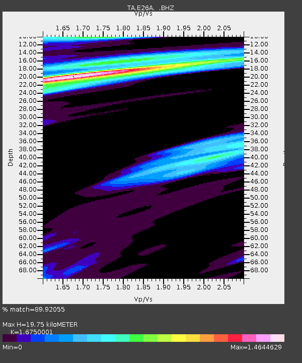
| Estimated Moho Depth: |
19.75 km |
| Estimated Crust Vp/Vs: |
1.68 |
| Assumed Crust Vp: |
6.402 km/s |
| Estimated Crust Vs: |
3.822 km/s |
| Estimated Crust Poisson's Ratio: |
0.22 |
|
| Radial Match: |
89.92055 % |
| Radial Bump: |
352 |
| Transverse Match: |
59.779034 % |
| Transverse Bump: |
400 |
| SOD ConfigId: |
2622 |
| Insert Time: |
2010-03-06 02:19:17.964 +0000 |
| GWidth: |
2.5 |
| Max Bumps: |
400 |
| Tol: |
0.001 |
|

Signal To Noise
| Channel | StoN | STA | LTA |
| TA:E26A: :BHZ:20090912T20:14:18.223986Z | 13.371688 | 1.8030757E-6 | 1.348428E-7 |
| TA:E26A: :BHN:20090912T20:14:18.223986Z | 1.3698068 | 7.153114E-7 | 5.221988E-7 |
| TA:E26A: :BHE:20090912T20:14:18.223986Z | 1.0537511 | 4.6954875E-7 | 4.455974E-7 |
| Arrivals |
| Ps | 2.2 SECOND |
| PpPs | 7.7 SECOND |
| PsPs/PpSs | 9.9 SECOND |


