You are here: Home > Network List > TA - USArray Transportable Network (new EarthScope stations) Stations List
> Station E26A Carlson Angus Ranch, Regent, ND, USA > Earthquake Result Viewer
E26A Carlson Angus Ranch, Regent, ND, USA - Earthquake Result Viewer
| Earthquake location: |
Southern Peru |
| Earthquake latitude/longitude: |
-15.0/-70.4 |
| Earthquake time(UTC): |
2009/07/12 (193) 06:12:47 GMT |
| Earthquake Depth: |
199 km |
| Earthquake Magnitude: |
5.7 MB, 6.1 MW, 6.1 MW |
| Earthquake Catalog/Contributor: |
WHDF/NEIC |
|
| Network: |
TA USArray Transportable Network (new EarthScope stations) |
| Station: |
E26A Carlson Angus Ranch, Regent, ND, USA |
| Lat/Lon: |
46.47 N/102.46 W |
| Elevation: |
806 m |
|
| Distance: |
67.7 deg |
| Az: |
336.665 deg |
| Baz: |
146.376 deg |
| Ray Param: |
0.056230985 |
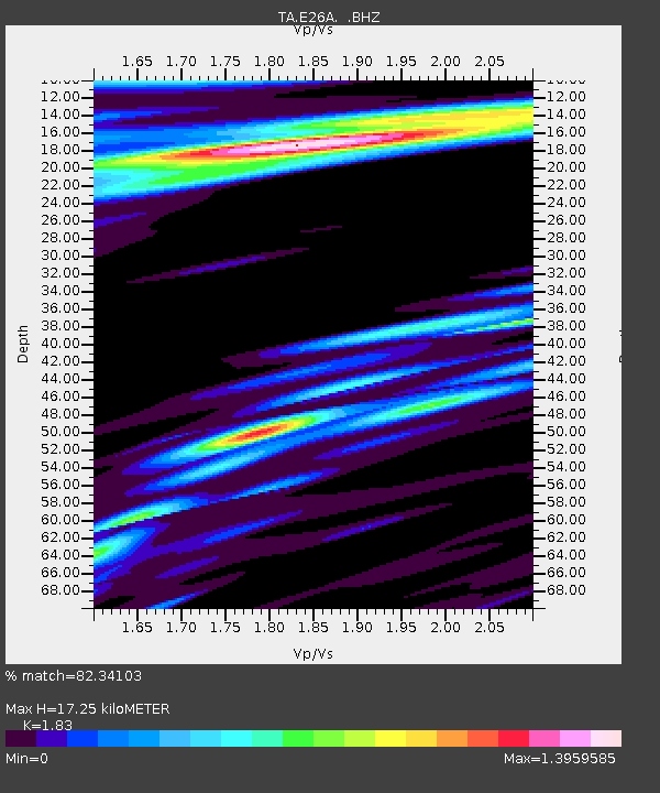
| Estimated Moho Depth: |
17.25 km |
| Estimated Crust Vp/Vs: |
1.83 |
| Assumed Crust Vp: |
6.402 km/s |
| Estimated Crust Vs: |
3.498 km/s |
| Estimated Crust Poisson's Ratio: |
0.29 |
|
| Radial Match: |
82.34103 % |
| Radial Bump: |
363 |
| Transverse Match: |
64.77887 % |
| Transverse Bump: |
400 |
| SOD ConfigId: |
2648 |
| Insert Time: |
2010-03-06 02:19:20.264 +0000 |
| GWidth: |
2.5 |
| Max Bumps: |
400 |
| Tol: |
0.001 |
|

Signal To Noise
| Channel | StoN | STA | LTA |
| TA:E26A: :BHZ:20090712T06:22:52.048994Z | 35.31239 | 2.112315E-6 | 5.981796E-8 |
| TA:E26A: :BHN:20090712T06:22:52.048994Z | 2.9493992 | 5.9165535E-7 | 2.00602E-7 |
| TA:E26A: :BHE:20090712T06:22:52.048994Z | 1.0887022 | 2.8701615E-7 | 2.6363145E-7 |
| Arrivals |
| Ps | 2.3 SECOND |
| PpPs | 7.3 SECOND |
| PsPs/PpSs | 9.7 SECOND |


