You are here: Home > Network List > LD - Lamont-Doherty Cooperative Seismographic Network Stations List
> Station MVL Millersville University, PA > Earthquake Result Viewer
MVL Millersville University, PA - Earthquake Result Viewer
| Earthquake location: |
North Atlantic Ocean |
| Earthquake latitude/longitude: |
13.4/-49.4 |
| Earthquake time(UTC): |
2017/07/27 (208) 17:53:25 GMT |
| Earthquake Depth: |
10 km |
| Earthquake Magnitude: |
5.9 Mww |
| Earthquake Catalog/Contributor: |
NEIC PDE/us |
|
| Network: |
LD Lamont-Doherty Cooperative Seismographic Network |
| Station: |
MVL Millersville University, PA |
| Lat/Lon: |
40.00 N/76.35 W |
| Elevation: |
91 m |
|
| Distance: |
35.6 deg |
| Az: |
323.186 deg |
| Baz: |
130.611 deg |
| Ray Param: |
0.07715419 |
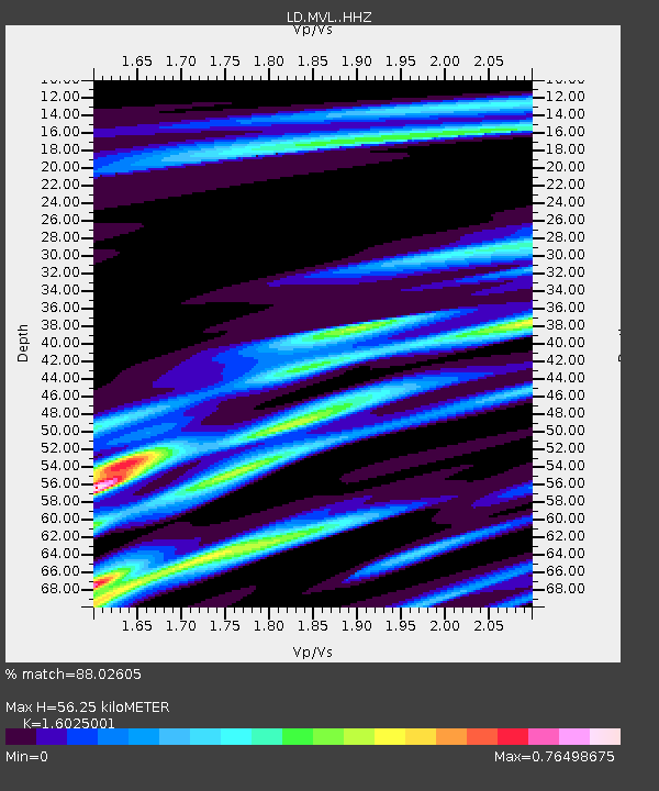
| Estimated Moho Depth: |
56.25 km |
| Estimated Crust Vp/Vs: |
1.60 |
| Assumed Crust Vp: |
6.419 km/s |
| Estimated Crust Vs: |
4.006 km/s |
| Estimated Crust Poisson's Ratio: |
0.18 |
|
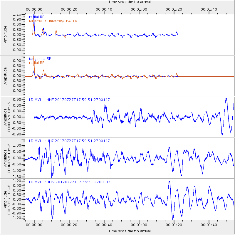
| Radial Match: |
88.02605 % |
| Radial Bump: |
207 |
| Transverse Match: |
82.085556 % |
| Transverse Bump: |
326 |
| SOD ConfigId: |
13570011 |
| Insert Time: |
2019-04-28 11:39:15.133 +0000 |
| GWidth: |
2.5 |
| Max Bumps: |
400 |
| Tol: |
0.001 |
|
Signal To Noise
| Channel | StoN | STA | LTA |
| LD:MVL: :HHZ:20170727T17:59:51.270011Z | 8.561415 | 4.5315656E-7 | 5.2930105E-8 |
| LD:MVL: :HHN:20170727T17:59:51.270011Z | 4.3342123 | 3.0020556E-7 | 6.926416E-8 |
| LD:MVL: :HHE:20170727T17:59:51.270011Z | 3.6722622 | 1.6945367E-7 | 4.614422E-8 |
| Arrivals |
| Ps | 5.7 SECOND |
| PpPs | 21 SECOND |
| PsPs/PpSs | 27 SECOND |


