You are here: Home > Network List > N4 - Central and EAstern US Network Stations List
> Station E28B Huff Hills, Mandan, ND, USA > Earthquake Result Viewer
E28B Huff Hills, Mandan, ND, USA - Earthquake Result Viewer
| Earthquake location: |
North Atlantic Ocean |
| Earthquake latitude/longitude: |
13.4/-49.4 |
| Earthquake time(UTC): |
2017/07/27 (208) 17:53:25 GMT |
| Earthquake Depth: |
10 km |
| Earthquake Magnitude: |
5.9 Mww |
| Earthquake Catalog/Contributor: |
NEIC PDE/us |
|
| Network: |
N4 Central and EAstern US Network |
| Station: |
E28B Huff Hills, Mandan, ND, USA |
| Lat/Lon: |
46.57 N/100.69 W |
| Elevation: |
704 m |
|
| Distance: |
54.1 deg |
| Az: |
318.345 deg |
| Baz: |
110.339 deg |
| Ray Param: |
0.06564299 |
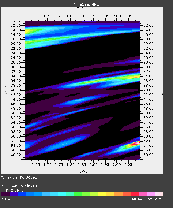
| Estimated Moho Depth: |
62.5 km |
| Estimated Crust Vp/Vs: |
2.10 |
| Assumed Crust Vp: |
6.438 km/s |
| Estimated Crust Vs: |
3.069 km/s |
| Estimated Crust Poisson's Ratio: |
0.35 |
|
| Radial Match: |
90.30893 % |
| Radial Bump: |
311 |
| Transverse Match: |
64.26472 % |
| Transverse Bump: |
400 |
| SOD ConfigId: |
13570011 |
| Insert Time: |
2019-04-28 11:39:48.641 +0000 |
| GWidth: |
2.5 |
| Max Bumps: |
400 |
| Tol: |
0.001 |
|

Signal To Noise
| Channel | StoN | STA | LTA |
| N4:E28B: :HHZ:20170727T18:02:18.76998Z | 9.003501 | 7.028641E-7 | 7.806564E-8 |
| N4:E28B: :HHN:20170727T18:02:18.76998Z | 0.6147319 | 1.5263865E-7 | 2.4830118E-7 |
| N4:E28B: :HHE:20170727T18:02:18.76998Z | 1.5463505 | 3.4281112E-7 | 2.2169044E-7 |
| Arrivals |
| Ps | 11 SECOND |
| PpPs | 29 SECOND |
| PsPs/PpSs | 40 SECOND |


