You are here: Home > Network List > N4 - Central and EAstern US Network Stations List
> Station G65A Princeton, ME, USA > Earthquake Result Viewer
G65A Princeton, ME, USA - Earthquake Result Viewer
| Earthquake location: |
North Atlantic Ocean |
| Earthquake latitude/longitude: |
13.4/-49.4 |
| Earthquake time(UTC): |
2017/07/27 (208) 17:53:25 GMT |
| Earthquake Depth: |
10 km |
| Earthquake Magnitude: |
5.9 Mww |
| Earthquake Catalog/Contributor: |
NEIC PDE/us |
|
| Network: |
N4 Central and EAstern US Network |
| Station: |
G65A Princeton, ME, USA |
| Lat/Lon: |
45.20 N/67.56 W |
| Elevation: |
78 m |
|
| Distance: |
35.3 deg |
| Az: |
337.531 deg |
| Baz: |
148.259 deg |
| Ray Param: |
0.07730374 |
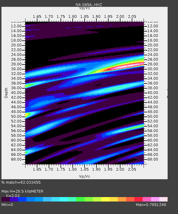
| Estimated Moho Depth: |
28.5 km |
| Estimated Crust Vp/Vs: |
2.03 |
| Assumed Crust Vp: |
6.419 km/s |
| Estimated Crust Vs: |
3.162 km/s |
| Estimated Crust Poisson's Ratio: |
0.34 |
|
| Radial Match: |
92.033455 % |
| Radial Bump: |
182 |
| Transverse Match: |
60.84896 % |
| Transverse Bump: |
400 |
| SOD ConfigId: |
13570011 |
| Insert Time: |
2019-04-28 11:39:56.933 +0000 |
| GWidth: |
2.5 |
| Max Bumps: |
400 |
| Tol: |
0.001 |
|

Signal To Noise
| Channel | StoN | STA | LTA |
| N4:G65A: :HHZ:20170727T17:59:48.770011Z | 2.771186 | 3.664868E-7 | 1.3224907E-7 |
| N4:G65A: :HHN:20170727T17:59:48.770011Z | 1.7397139 | 1.7066975E-7 | 9.810219E-8 |
| N4:G65A: :HHE:20170727T17:59:48.770011Z | 1.176006 | 1.3469743E-7 | 1.1453805E-7 |
| Arrivals |
| Ps | 4.9 SECOND |
| PpPs | 13 SECOND |
| PsPs/PpSs | 17 SECOND |


