You are here: Home > Network List > N4 - Central and EAstern US Network Stations List
> Station J54A Appleton, NY, USA > Earthquake Result Viewer
J54A Appleton, NY, USA - Earthquake Result Viewer
| Earthquake location: |
North Atlantic Ocean |
| Earthquake latitude/longitude: |
13.4/-49.4 |
| Earthquake time(UTC): |
2017/07/27 (208) 17:53:25 GMT |
| Earthquake Depth: |
10 km |
| Earthquake Magnitude: |
5.9 Mww |
| Earthquake Catalog/Contributor: |
NEIC PDE/us |
|
| Network: |
N4 Central and EAstern US Network |
| Station: |
J54A Appleton, NY, USA |
| Lat/Lon: |
43.27 N/78.64 W |
| Elevation: |
112 m |
|
| Distance: |
39.0 deg |
| Az: |
325.428 deg |
| Baz: |
130.88 deg |
| Ray Param: |
0.075236306 |
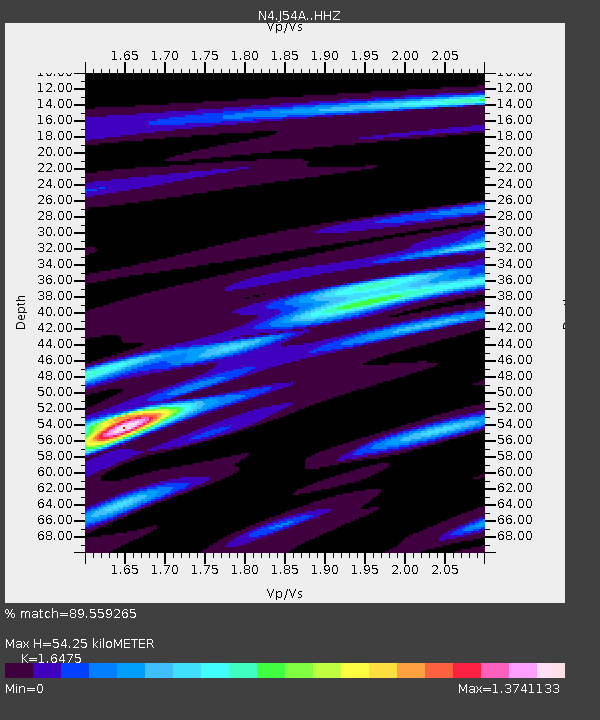
| Estimated Moho Depth: |
54.25 km |
| Estimated Crust Vp/Vs: |
1.65 |
| Assumed Crust Vp: |
6.419 km/s |
| Estimated Crust Vs: |
3.896 km/s |
| Estimated Crust Poisson's Ratio: |
0.21 |
|
| Radial Match: |
89.559265 % |
| Radial Bump: |
263 |
| Transverse Match: |
41.947445 % |
| Transverse Bump: |
400 |
| SOD ConfigId: |
13570011 |
| Insert Time: |
2019-04-28 11:40:03.957 +0000 |
| GWidth: |
2.5 |
| Max Bumps: |
400 |
| Tol: |
0.001 |
|

Signal To Noise
| Channel | StoN | STA | LTA |
| N4:J54A: :HHZ:20170727T18:00:20.349998Z | 2.6434429 | 2.763343E-7 | 1.0453576E-7 |
| N4:J54A: :HHN:20170727T18:00:20.349998Z | 1.8709866 | 1.8695347E-7 | 9.99224E-8 |
| N4:J54A: :HHE:20170727T18:00:20.349998Z | 1.5022805 | 1.4324812E-7 | 9.5353776E-8 |
| Arrivals |
| Ps | 5.9 SECOND |
| PpPs | 21 SECOND |
| PsPs/PpSs | 27 SECOND |


