You are here: Home > Network List > N4 - Central and EAstern US Network Stations List
> Station J61A Chester > Earthquake Result Viewer
J61A Chester - Earthquake Result Viewer
| Earthquake location: |
North Atlantic Ocean |
| Earthquake latitude/longitude: |
13.4/-49.4 |
| Earthquake time(UTC): |
2017/07/27 (208) 17:53:25 GMT |
| Earthquake Depth: |
10 km |
| Earthquake Magnitude: |
5.9 Mww |
| Earthquake Catalog/Contributor: |
NEIC PDE/us |
|
| Network: |
N4 Central and EAstern US Network |
| Station: |
J61A Chester |
| Lat/Lon: |
43.35 N/72.55 W |
| Elevation: |
253 m |
|
| Distance: |
35.9 deg |
| Az: |
330.681 deg |
| Baz: |
139.214 deg |
| Ray Param: |
0.07696676 |
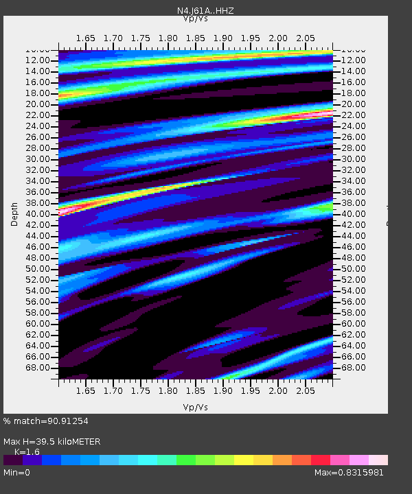
| Estimated Moho Depth: |
39.5 km |
| Estimated Crust Vp/Vs: |
1.60 |
| Assumed Crust Vp: |
6.419 km/s |
| Estimated Crust Vs: |
4.012 km/s |
| Estimated Crust Poisson's Ratio: |
0.18 |
|
| Radial Match: |
90.91254 % |
| Radial Bump: |
340 |
| Transverse Match: |
53.11158 % |
| Transverse Bump: |
400 |
| SOD ConfigId: |
13570011 |
| Insert Time: |
2019-04-28 11:40:08.306 +0000 |
| GWidth: |
2.5 |
| Max Bumps: |
400 |
| Tol: |
0.001 |
|

Signal To Noise
| Channel | StoN | STA | LTA |
| N4:J61A: :HHZ:20170727T17:59:54.189994Z | 3.3928988 | 3.5037158E-7 | 1.03266146E-7 |
| N4:J61A: :HHN:20170727T17:59:54.189994Z | 2.801244 | 2.425792E-7 | 8.6596955E-8 |
| N4:J61A: :HHE:20170727T17:59:54.189994Z | 2.5378344 | 2.3557854E-7 | 9.28266E-8 |
| Arrivals |
| Ps | 4.0 SECOND |
| PpPs | 15 SECOND |
| PsPs/PpSs | 19 SECOND |


