You are here: Home > Network List > N4 - Central and EAstern US Network Stations List
> Station S51A Beattyville, KY, USA > Earthquake Result Viewer
S51A Beattyville, KY, USA - Earthquake Result Viewer
| Earthquake location: |
North Atlantic Ocean |
| Earthquake latitude/longitude: |
13.4/-49.4 |
| Earthquake time(UTC): |
2017/07/27 (208) 17:53:25 GMT |
| Earthquake Depth: |
10 km |
| Earthquake Magnitude: |
5.9 Mww |
| Earthquake Catalog/Contributor: |
NEIC PDE/us |
|
| Network: |
N4 Central and EAstern US Network |
| Station: |
S51A Beattyville, KY, USA |
| Lat/Lon: |
37.64 N/83.59 W |
| Elevation: |
286 m |
|
| Distance: |
38.9 deg |
| Az: |
314.637 deg |
| Baz: |
119.269 deg |
| Ray Param: |
0.07531553 |
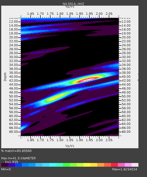
| Estimated Moho Depth: |
41.5 km |
| Estimated Crust Vp/Vs: |
1.93 |
| Assumed Crust Vp: |
6.476 km/s |
| Estimated Crust Vs: |
3.347 km/s |
| Estimated Crust Poisson's Ratio: |
0.32 |
|
| Radial Match: |
90.65598 % |
| Radial Bump: |
342 |
| Transverse Match: |
53.561543 % |
| Transverse Bump: |
400 |
| SOD ConfigId: |
13570011 |
| Insert Time: |
2019-04-28 11:40:48.944 +0000 |
| GWidth: |
2.5 |
| Max Bumps: |
400 |
| Tol: |
0.001 |
|

Signal To Noise
| Channel | StoN | STA | LTA |
| N4:S51A: :HHZ:20170727T18:00:19.270011Z | 4.7452607 | 3.577977E-7 | 7.5401054E-8 |
| N4:S51A: :HHN:20170727T18:00:19.270011Z | 1.5783027 | 8.497264E-8 | 5.3837987E-8 |
| N4:S51A: :HHE:20170727T18:00:19.270011Z | 4.452173 | 1.785084E-7 | 4.0094665E-8 |
| Arrivals |
| Ps | 6.4 SECOND |
| PpPs | 18 SECOND |
| PsPs/PpSs | 24 SECOND |


