You are here: Home > Network List > N4 - Central and EAstern US Network Stations List
> Station V52A Sevierville, TN, USA > Earthquake Result Viewer
V52A Sevierville, TN, USA - Earthquake Result Viewer
| Earthquake location: |
North Atlantic Ocean |
| Earthquake latitude/longitude: |
13.4/-49.4 |
| Earthquake time(UTC): |
2017/07/27 (208) 17:53:25 GMT |
| Earthquake Depth: |
10 km |
| Earthquake Magnitude: |
5.9 Mww |
| Earthquake Catalog/Contributor: |
NEIC PDE/us |
|
| Network: |
N4 Central and EAstern US Network |
| Station: |
V52A Sevierville, TN, USA |
| Lat/Lon: |
35.84 N/83.60 W |
| Elevation: |
328 m |
|
| Distance: |
38.0 deg |
| Az: |
312.094 deg |
| Baz: |
117.275 deg |
| Ray Param: |
0.07580563 |
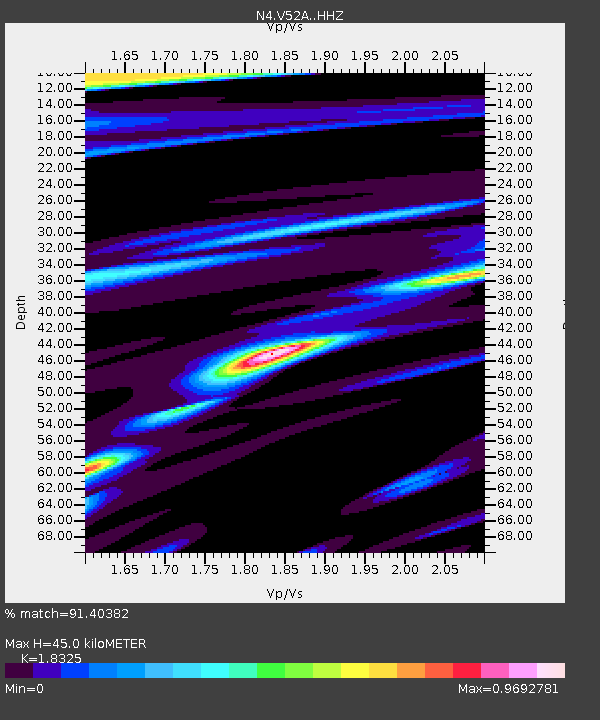
| Estimated Moho Depth: |
45.0 km |
| Estimated Crust Vp/Vs: |
1.83 |
| Assumed Crust Vp: |
6.35 km/s |
| Estimated Crust Vs: |
3.465 km/s |
| Estimated Crust Poisson's Ratio: |
0.29 |
|
| Radial Match: |
91.40382 % |
| Radial Bump: |
306 |
| Transverse Match: |
51.94606 % |
| Transverse Bump: |
400 |
| SOD ConfigId: |
13570011 |
| Insert Time: |
2019-04-28 11:41:03.555 +0000 |
| GWidth: |
2.5 |
| Max Bumps: |
400 |
| Tol: |
0.001 |
|

Signal To Noise
| Channel | StoN | STA | LTA |
| N4:V52A: :HHZ:20170727T18:00:12.159995Z | 5.2429996 | 3.2107226E-7 | 6.1238275E-8 |
| N4:V52A: :HHN:20170727T18:00:12.159995Z | 0.96508014 | 1.0035066E-7 | 1.03981684E-7 |
| N4:V52A: :HHE:20170727T18:00:12.159995Z | 3.8553178 | 1.9695369E-7 | 5.108624E-8 |
| Arrivals |
| Ps | 6.3 SECOND |
| PpPs | 19 SECOND |
| PsPs/PpSs | 25 SECOND |


