You are here: Home > Network List > NM - Cooperative New Madrid Seismic Network Stations List
> Station MGMO Mountain Grove, MO > Earthquake Result Viewer
MGMO Mountain Grove, MO - Earthquake Result Viewer
| Earthquake location: |
North Atlantic Ocean |
| Earthquake latitude/longitude: |
13.4/-49.4 |
| Earthquake time(UTC): |
2017/07/27 (208) 17:53:25 GMT |
| Earthquake Depth: |
10 km |
| Earthquake Magnitude: |
5.9 Mww |
| Earthquake Catalog/Contributor: |
NEIC PDE/us |
|
| Network: |
NM Cooperative New Madrid Seismic Network |
| Station: |
MGMO Mountain Grove, MO |
| Lat/Lon: |
37.15 N/92.27 W |
| Elevation: |
453 m |
|
| Distance: |
44.9 deg |
| Az: |
309.646 deg |
| Baz: |
110.295 deg |
| Ray Param: |
0.07160854 |
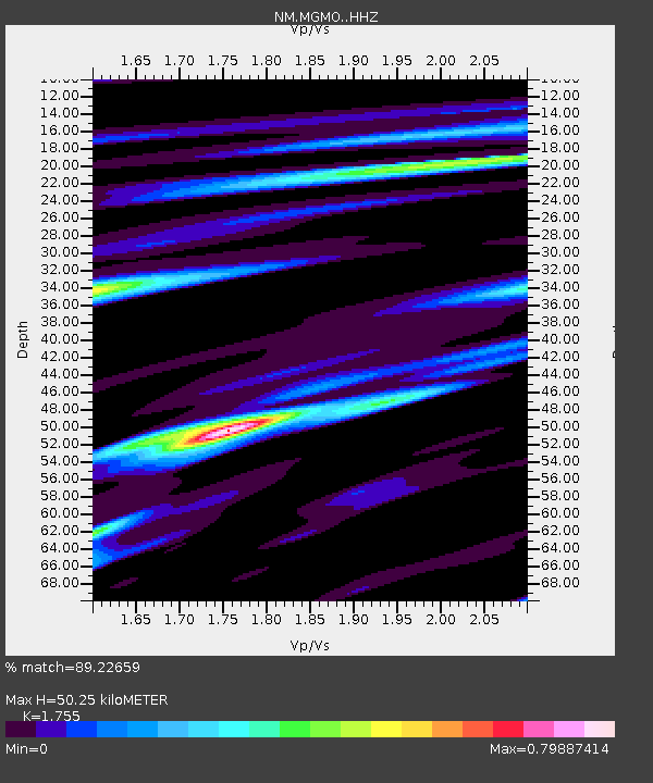
| Estimated Moho Depth: |
50.25 km |
| Estimated Crust Vp/Vs: |
1.75 |
| Assumed Crust Vp: |
6.53 km/s |
| Estimated Crust Vs: |
3.721 km/s |
| Estimated Crust Poisson's Ratio: |
0.26 |
|
| Radial Match: |
89.22659 % |
| Radial Bump: |
353 |
| Transverse Match: |
75.220375 % |
| Transverse Bump: |
400 |
| SOD ConfigId: |
13570011 |
| Insert Time: |
2019-04-28 11:41:23.831 +0000 |
| GWidth: |
2.5 |
| Max Bumps: |
400 |
| Tol: |
0.001 |
|

Signal To Noise
| Channel | StoN | STA | LTA |
| NM:MGMO: :HHZ:20170727T18:01:08.849998Z | 5.161413 | 3.6738655E-7 | 7.117945E-8 |
| NM:MGMO: :HHN:20170727T18:01:08.849998Z | 2.3447516 | 1.5878601E-7 | 6.771976E-8 |
| NM:MGMO: :HHE:20170727T18:01:08.849998Z | 3.9988217 | 2.1821509E-7 | 5.4569846E-8 |
| Arrivals |
| Ps | 6.2 SECOND |
| PpPs | 20 SECOND |
| PsPs/PpSs | 26 SECOND |


