You are here: Home > Network List > TA - USArray Transportable Network (new EarthScope stations) Stations List
> Station E25A Miller Ranch, Amidon, ND, USA > Earthquake Result Viewer
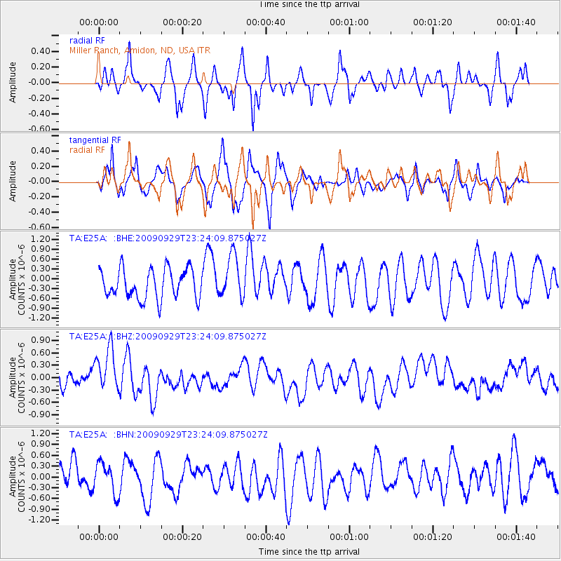
E25A Miller Ranch, Amidon, ND, USA - Earthquake Result Viewer
*The percent match for this event was below the threshold and hence no stack was calculated.
| Earthquake location: |
Tonga Islands |
| Earthquake latitude/longitude: |
-15.6/-173.4 |
| Earthquake time(UTC): |
2009/09/29 (272) 23:11:51 GMT |
| Earthquake Depth: |
10 km |
| Earthquake Magnitude: |
5.5 MB |
| Earthquake Catalog/Contributor: |
WHDF/NEIC |
|
| Network: |
TA USArray Transportable Network (new EarthScope stations) |
| Station: |
E25A Miller Ranch, Amidon, ND, USA |
| Lat/Lon: |
46.50 N/103.40 W |
| Elevation: |
885 m |
|
| Distance: |
88.0 deg |
| Az: |
40.495 deg |
| Baz: |
244.94 deg |
| Ray Param: |
$rayparam |
*The percent match for this event was below the threshold and hence was not used in the summary stack. |
|
| Radial Match: |
57.609303 % |
| Radial Bump: |
332 |
| Transverse Match: |
49.566326 % |
| Transverse Bump: |
395 |
| SOD ConfigId: |
2622 |
| Insert Time: |
2010-03-06 02:20:33.265 +0000 |
| GWidth: |
2.5 |
| Max Bumps: |
400 |
| Tol: |
0.001 |
|
Signal To Noise
| Channel | StoN | STA | LTA |
| TA:E25A: :BHZ:20090929T23:24:09.875027Z | 1.7752075 | 6.200004E-7 | 3.4925515E-7 |
| TA:E25A: :BHN:20090929T23:24:09.875027Z | 1.0770054 | 4.3308023E-7 | 4.0211518E-7 |
| TA:E25A: :BHE:20090929T23:24:09.875027Z | 1.4971808 | 6.754312E-7 | 4.5113535E-7 |
| Arrivals |
| Ps | |
| PpPs | |
| PsPs/PpSs | |


