You are here: Home > Network List > TA - USArray Transportable Network (new EarthScope stations) Stations List
> Station I17K Unalakleet, AK, USA > Earthquake Result Viewer
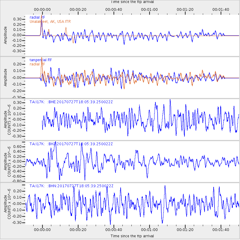
I17K Unalakleet, AK, USA - Earthquake Result Viewer
*The percent match for this event was below the threshold and hence no stack was calculated.
| Earthquake location: |
North Atlantic Ocean |
| Earthquake latitude/longitude: |
13.4/-49.4 |
| Earthquake time(UTC): |
2017/07/27 (208) 17:53:25 GMT |
| Earthquake Depth: |
10 km |
| Earthquake Magnitude: |
5.9 Mww |
| Earthquake Catalog/Contributor: |
NEIC PDE/us |
|
| Network: |
TA USArray Transportable Network (new EarthScope stations) |
| Station: |
I17K Unalakleet, AK, USA |
| Lat/Lon: |
63.89 N/160.70 W |
| Elevation: |
105 m |
|
| Distance: |
87.2 deg |
| Az: |
335.623 deg |
| Baz: |
65.186 deg |
| Ray Param: |
$rayparam |
*The percent match for this event was below the threshold and hence was not used in the summary stack. |
|
| Radial Match: |
68.576904 % |
| Radial Bump: |
400 |
| Transverse Match: |
67.34371 % |
| Transverse Bump: |
400 |
| SOD ConfigId: |
13570011 |
| Insert Time: |
2019-04-28 11:44:20.435 +0000 |
| GWidth: |
2.5 |
| Max Bumps: |
400 |
| Tol: |
0.001 |
|
Signal To Noise
| Channel | StoN | STA | LTA |
| TA:I17K: :BHZ:20170727T18:05:39.250022Z | 3.5635834 | 2.7943193E-7 | 7.841319E-8 |
| TA:I17K: :BHN:20170727T18:05:39.250022Z | 1.1896416 | 8.996099E-8 | 7.562024E-8 |
| TA:I17K: :BHE:20170727T18:05:39.250022Z | 1.1331213 | 9.656767E-8 | 8.5222716E-8 |
| Arrivals |
| Ps | |
| PpPs | |
| PsPs/PpSs | |


