You are here: Home > Network List > TA - USArray Transportable Network (new EarthScope stations) Stations List
> Station K13K Kusilvak Mountain, AK, USA > Earthquake Result Viewer
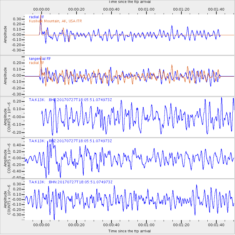
K13K Kusilvak Mountain, AK, USA - Earthquake Result Viewer
*The percent match for this event was below the threshold and hence no stack was calculated.
| Earthquake location: |
North Atlantic Ocean |
| Earthquake latitude/longitude: |
13.4/-49.4 |
| Earthquake time(UTC): |
2017/07/27 (208) 17:53:25 GMT |
| Earthquake Depth: |
10 km |
| Earthquake Magnitude: |
5.9 Mww |
| Earthquake Catalog/Contributor: |
NEIC PDE/us |
|
| Network: |
TA USArray Transportable Network (new EarthScope stations) |
| Station: |
K13K Kusilvak Mountain, AK, USA |
| Lat/Lon: |
61.93 N/164.66 W |
| Elevation: |
204 m |
|
| Distance: |
89.7 deg |
| Az: |
334.681 deg |
| Baz: |
61.638 deg |
| Ray Param: |
$rayparam |
*The percent match for this event was below the threshold and hence was not used in the summary stack. |
|
| Radial Match: |
67.235695 % |
| Radial Bump: |
400 |
| Transverse Match: |
52.739162 % |
| Transverse Bump: |
400 |
| SOD ConfigId: |
13570011 |
| Insert Time: |
2019-04-28 11:44:34.479 +0000 |
| GWidth: |
2.5 |
| Max Bumps: |
400 |
| Tol: |
0.001 |
|
Signal To Noise
| Channel | StoN | STA | LTA |
| TA:K13K: :BHZ:20170727T18:05:51.074973Z | 3.5655274 | 2.881033E-7 | 8.0802444E-8 |
| TA:K13K: :BHN:20170727T18:05:51.074973Z | 1.0684633 | 1.1942122E-7 | 1.11769126E-7 |
| TA:K13K: :BHE:20170727T18:05:51.074973Z | 0.85602385 | 8.207184E-8 | 9.587565E-8 |
| Arrivals |
| Ps | |
| PpPs | |
| PsPs/PpSs | |


