You are here: Home > Network List > TA - USArray Transportable Network (new EarthScope stations) Stations List
> Station MDND Maddock, ND, USA > Earthquake Result Viewer
MDND Maddock, ND, USA - Earthquake Result Viewer
| Earthquake location: |
North Atlantic Ocean |
| Earthquake latitude/longitude: |
13.4/-49.4 |
| Earthquake time(UTC): |
2017/07/27 (208) 17:53:25 GMT |
| Earthquake Depth: |
10 km |
| Earthquake Magnitude: |
5.9 Mww |
| Earthquake Catalog/Contributor: |
NEIC PDE/us |
|
| Network: |
TA USArray Transportable Network (new EarthScope stations) |
| Station: |
MDND Maddock, ND, USA |
| Lat/Lon: |
47.85 N/99.60 W |
| Elevation: |
479 m |
|
| Distance: |
53.9 deg |
| Az: |
320.146 deg |
| Baz: |
112.195 deg |
| Ray Param: |
0.06579371 |
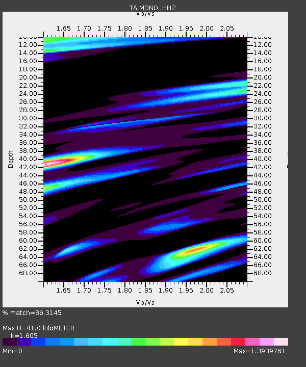
| Estimated Moho Depth: |
41.0 km |
| Estimated Crust Vp/Vs: |
1.61 |
| Assumed Crust Vp: |
6.53 km/s |
| Estimated Crust Vs: |
4.069 km/s |
| Estimated Crust Poisson's Ratio: |
0.18 |
|
| Radial Match: |
86.3145 % |
| Radial Bump: |
328 |
| Transverse Match: |
59.27276 % |
| Transverse Bump: |
394 |
| SOD ConfigId: |
13570011 |
| Insert Time: |
2019-04-28 11:45:01.210 +0000 |
| GWidth: |
2.5 |
| Max Bumps: |
400 |
| Tol: |
0.001 |
|
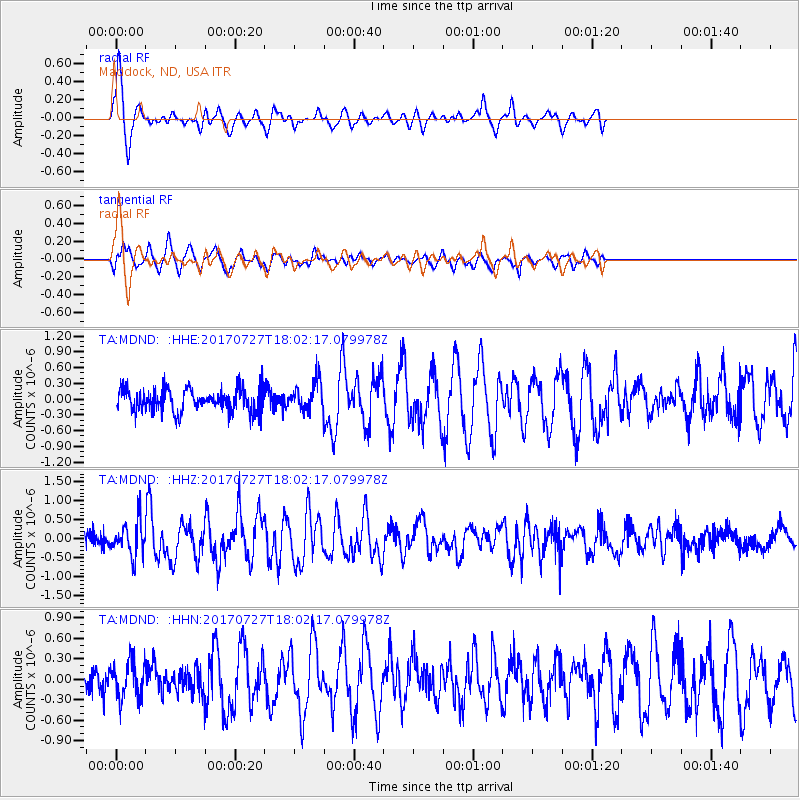
Signal To Noise
| Channel | StoN | STA | LTA |
| TA:MDND: :HHZ:20170727T18:02:17.079978Z | 2.452006 | 4.5119458E-7 | 1.8401039E-7 |
| TA:MDND: :HHN:20170727T18:02:17.079978Z | 1.2818445 | 2.6278147E-7 | 2.050026E-7 |
| TA:MDND: :HHE:20170727T18:02:17.079978Z | 1.4538423 | 3.096191E-7 | 2.129661E-7 |
| Arrivals |
| Ps | 4.0 SECOND |
| PpPs | 15 SECOND |
| PsPs/PpSs | 19 SECOND |


