You are here: Home > Network List > CI - Caltech Regional Seismic Network Stations List
> Station CHF Chilao Flat Rngr Sta, Altadena, CA, USA > Earthquake Result Viewer
CHF Chilao Flat Rngr Sta, Altadena, CA, USA - Earthquake Result Viewer
| Earthquake location: |
Kuril Islands |
| Earthquake latitude/longitude: |
44.3/148.4 |
| Earthquake time(UTC): |
2001/05/25 (145) 00:40:50 GMT |
| Earthquake Depth: |
33 km |
| Earthquake Magnitude: |
6.1 MB, 6.7 MS, 6.7 MW, 6.6 MW |
| Earthquake Catalog/Contributor: |
WHDF/NEIC |
|
| Network: |
CI Caltech Regional Seismic Network |
| Station: |
CHF Chilao Flat Rngr Sta, Altadena, CA, USA |
| Lat/Lon: |
34.33 N/118.03 W |
| Elevation: |
1594 m |
|
| Distance: |
69.3 deg |
| Az: |
61.992 deg |
| Baz: |
309.961 deg |
| Ray Param: |
0.055685014 |
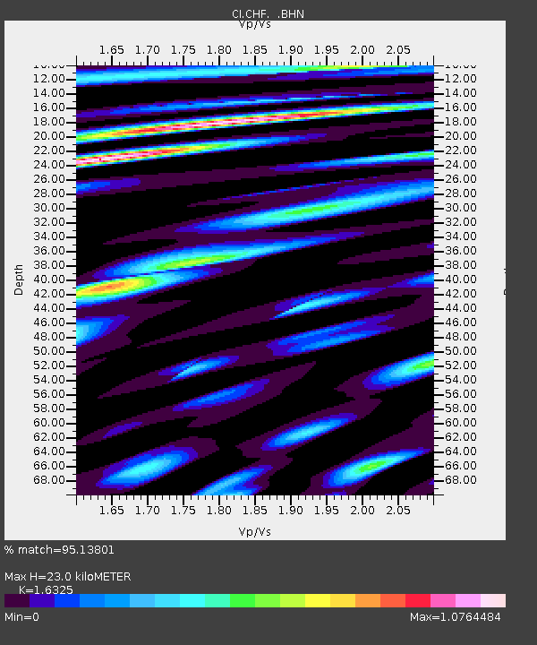
| Estimated Moho Depth: |
23.0 km |
| Estimated Crust Vp/Vs: |
1.63 |
| Assumed Crust Vp: |
6.1 km/s |
| Estimated Crust Vs: |
3.737 km/s |
| Estimated Crust Poisson's Ratio: |
0.20 |
|
| Radial Match: |
95.13801 % |
| Radial Bump: |
400 |
| Transverse Match: |
86.006424 % |
| Transverse Bump: |
400 |
| SOD ConfigId: |
3770 |
| Insert Time: |
2010-02-26 01:21:58.419 +0000 |
| GWidth: |
2.5 |
| Max Bumps: |
400 |
| Tol: |
0.001 |
|
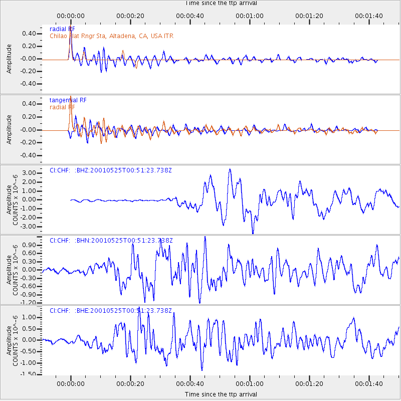
Signal To Noise
| Channel | StoN | STA | LTA |
| CI:CHF: :BHN:20010525T00:51:23.738Z | 0.8896874 | 6.182495E-8 | 6.949064E-8 |
| CI:CHF: :BHE:20010525T00:51:23.738Z | 2.1087162 | 1.1771155E-7 | 5.5821424E-8 |
| CI:CHF: :BHZ:20010525T00:51:23.738Z | 1.633595 | 1.1293297E-7 | 6.913156E-8 |
| Arrivals |
| Ps | 2.5 SECOND |
| PpPs | 9.6 SECOND |
| PsPs/PpSs | 12 SECOND |


