You are here: Home > Network List > TA - USArray Transportable Network (new EarthScope stations) Stations List
> Station Q32M Nakina River, BC, CAN > Earthquake Result Viewer
Q32M Nakina River, BC, CAN - Earthquake Result Viewer
| Earthquake location: |
North Atlantic Ocean |
| Earthquake latitude/longitude: |
13.4/-49.4 |
| Earthquake time(UTC): |
2017/07/27 (208) 17:53:25 GMT |
| Earthquake Depth: |
10 km |
| Earthquake Magnitude: |
5.9 Mww |
| Earthquake Catalog/Contributor: |
NEIC PDE/us |
|
| Network: |
TA USArray Transportable Network (new EarthScope stations) |
| Station: |
Q32M Nakina River, BC, CAN |
| Lat/Lon: |
58.96 N/132.27 W |
| Elevation: |
1951 m |
|
| Distance: |
75.0 deg |
| Az: |
327.834 deg |
| Baz: |
89.033 deg |
| Ray Param: |
0.051963937 |
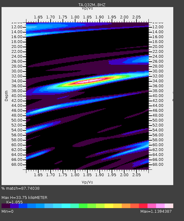
| Estimated Moho Depth: |
33.75 km |
| Estimated Crust Vp/Vs: |
1.86 |
| Assumed Crust Vp: |
6.597 km/s |
| Estimated Crust Vs: |
3.557 km/s |
| Estimated Crust Poisson's Ratio: |
0.30 |
|
| Radial Match: |
87.74038 % |
| Radial Bump: |
400 |
| Transverse Match: |
80.18152 % |
| Transverse Bump: |
400 |
| SOD ConfigId: |
13570011 |
| Insert Time: |
2019-04-28 11:45:31.996 +0000 |
| GWidth: |
2.5 |
| Max Bumps: |
400 |
| Tol: |
0.001 |
|

Signal To Noise
| Channel | StoN | STA | LTA |
| TA:Q32M: :BHZ:20170727T18:04:34.750022Z | 2.4136913 | 2.654934E-7 | 1.0999477E-7 |
| TA:Q32M: :BHN:20170727T18:04:34.750022Z | 0.53349495 | 5.1695498E-8 | 9.689969E-8 |
| TA:Q32M: :BHE:20170727T18:04:34.750022Z | 1.0307592 | 7.667254E-8 | 7.438454E-8 |
| Arrivals |
| Ps | 4.5 SECOND |
| PpPs | 14 SECOND |
| PsPs/PpSs | 19 SECOND |


