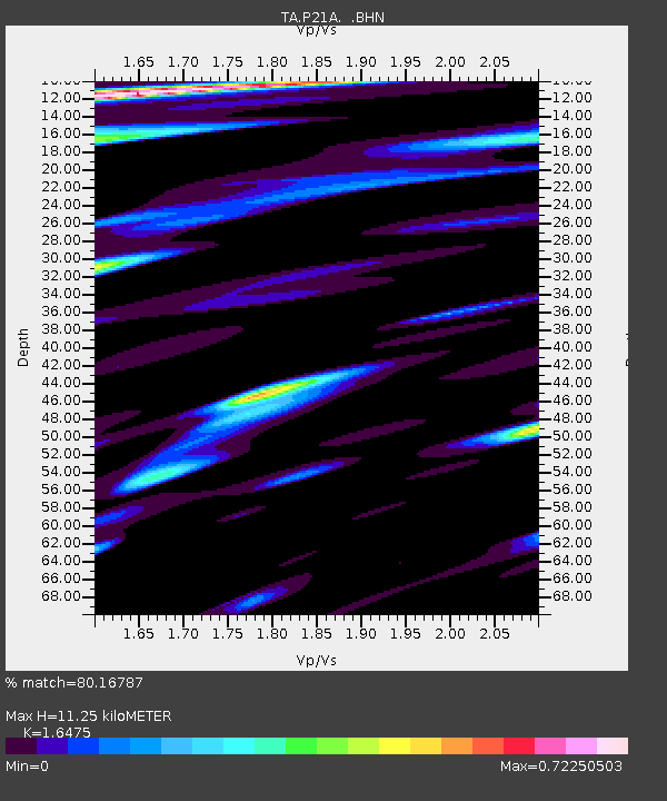
P21A Newcastle, CO, USA - Earthquake Result Viewer
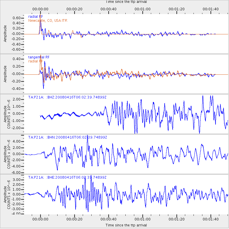
Earthquake location: Andreanof Islands, Aleutian Is.
Earthquake latitude/longitude: 51.9/-179.2
Earthquake time(UTC): 2008/04/16 (107) 05:54:19 GMT
Earthquake Depth: 13 km
Earthquake Magnitude: 6.1 MB, 6.5 MS, 6.6 MW, 6.6 MW
Earthquake Catalog/Contributor: WHDF/NEIC
Network: TA USArray Transportable Network (new EarthScope stations)
Station: P21A Newcastle, CO, USA
Lat/Lon: 39.52 N/107.45 W
Elevation: 2097 m
Distance: 49.6 deg
Az: 74.583 deg
Baz: 309.409 deg
Ray Param: 0.06857448
Estimated Moho Depth: 11.25 km
Estimated Crust Vp/Vs: 1.65
Assumed Crust Vp: 6.306 km/s
Estimated Crust Vs: 3.828 km/s
Estimated Crust Poisson's Ratio: 0.21
Radial Match: 80.16787 %
Radial Bump: 400
Transverse Match: 73.55023 %
Transverse Bump: 400
SOD ConfigId: 2504
Insert Time: 2010-03-06 02:21:04.639 +0000
GWidth: 2.5
Max Bumps: 400
Tol: 0.001

Signal To Noise

ChannelStoNSTALTA
TA:P21A: :BHN:20080416T06:02:39.74899Z3.23731546.3963563E-71.9758212E-7
TA:P21A: :BHE:20080416T06:02:39.74899Z1.6833664.2223354E-72.5082696E-7
TA:P21A: :BHZ:20080416T06:02:39.74899Z1.05867062.384251E-72.2521176E-7
Arrivals
Ps1.2 SECOND
PpPs4.4 SECOND
PsPs/PpSs5.7 SECOND