You are here: Home > Network List > TA - USArray Transportable Network (new EarthScope stations) Stations List
> Station R33M Jennings River, BC, CAN > Earthquake Result Viewer
R33M Jennings River, BC, CAN - Earthquake Result Viewer
| Earthquake location: |
North Atlantic Ocean |
| Earthquake latitude/longitude: |
13.4/-49.4 |
| Earthquake time(UTC): |
2017/07/27 (208) 17:53:25 GMT |
| Earthquake Depth: |
10 km |
| Earthquake Magnitude: |
5.9 Mww |
| Earthquake Catalog/Contributor: |
NEIC PDE/us |
|
| Network: |
TA USArray Transportable Network (new EarthScope stations) |
| Station: |
R33M Jennings River, BC, CAN |
| Lat/Lon: |
59.39 N/130.97 W |
| Elevation: |
1437 m |
|
| Distance: |
74.3 deg |
| Az: |
328.282 deg |
| Baz: |
90.268 deg |
| Ray Param: |
0.052415445 |
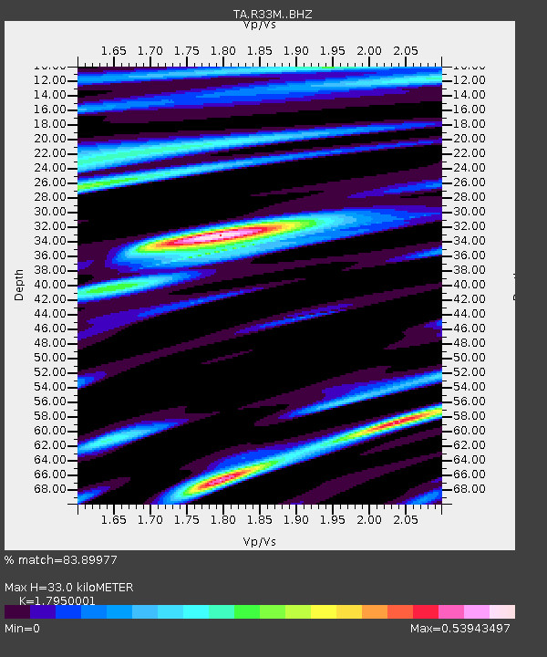
| Estimated Moho Depth: |
33.0 km |
| Estimated Crust Vp/Vs: |
1.80 |
| Assumed Crust Vp: |
6.597 km/s |
| Estimated Crust Vs: |
3.675 km/s |
| Estimated Crust Poisson's Ratio: |
0.27 |
|
| Radial Match: |
83.89977 % |
| Radial Bump: |
400 |
| Transverse Match: |
78.89741 % |
| Transverse Bump: |
400 |
| SOD ConfigId: |
13570011 |
| Insert Time: |
2019-04-28 11:45:34.358 +0000 |
| GWidth: |
2.5 |
| Max Bumps: |
400 |
| Tol: |
0.001 |
|

Signal To Noise
| Channel | StoN | STA | LTA |
| TA:R33M: :BHZ:20170727T18:04:30.849998Z | 4.6972265 | 2.6587273E-7 | 5.6602065E-8 |
| TA:R33M: :BHN:20170727T18:04:30.849998Z | 1.2923254 | 6.260734E-8 | 4.8445497E-8 |
| TA:R33M: :BHE:20170727T18:04:30.849998Z | 2.1844196 | 1.10303404E-7 | 5.049552E-8 |
| Arrivals |
| Ps | 4.1 SECOND |
| PpPs | 14 SECOND |
| PsPs/PpSs | 18 SECOND |


