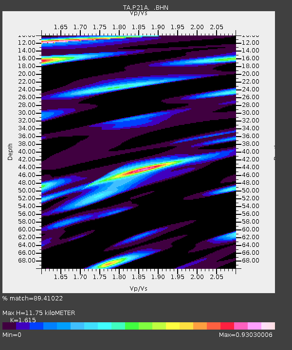
P21A Newcastle, CO, USA - Earthquake Result Viewer
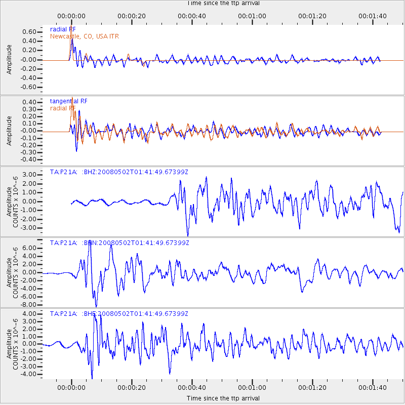
Earthquake location: Andreanof Islands, Aleutian Is.
Earthquake latitude/longitude: 51.9/-177.5
Earthquake time(UTC): 2008/05/02 (123) 01:33:37 GMT
Earthquake Depth: 14 km
Earthquake Magnitude: 6.3 MB, 6.8 MS, 6.6 MW, 6.6 MW
Earthquake Catalog/Contributor: WHDF/NEIC
Network: TA USArray Transportable Network (new EarthScope stations)
Station: P21A Newcastle, CO, USA
Lat/Lon: 39.52 N/107.45 W
Elevation: 2097 m
Distance: 48.6 deg
Az: 75.63 deg
Baz: 309.046 deg
Ray Param: 0.069211856
Estimated Moho Depth: 11.75 km
Estimated Crust Vp/Vs: 1.62
Assumed Crust Vp: 6.306 km/s
Estimated Crust Vs: 3.905 km/s
Estimated Crust Poisson's Ratio: 0.19
Radial Match: 89.41022 %
Radial Bump: 400
Transverse Match: 77.5006 %
Transverse Bump: 400
SOD ConfigId: 2504
Insert Time: 2010-03-06 02:21:07.702 +0000
GWidth: 2.5
Max Bumps: 400
Tol: 0.001

Signal To Noise

ChannelStoNSTALTA
TA:P21A: :BHN:20080502T01:41:49.67399Z11.7563391.5415175E-61.3112223E-7
TA:P21A: :BHE:20080502T01:41:49.67399Z1.96330654.9534214E-72.5229997E-7
TA:P21A: :BHZ:20080502T01:41:49.67399Z2.45674754.5984373E-71.8717581E-7
Arrivals
Ps1.2 SECOND
PpPs4.6 SECOND
PsPs/PpSs5.8 SECOND