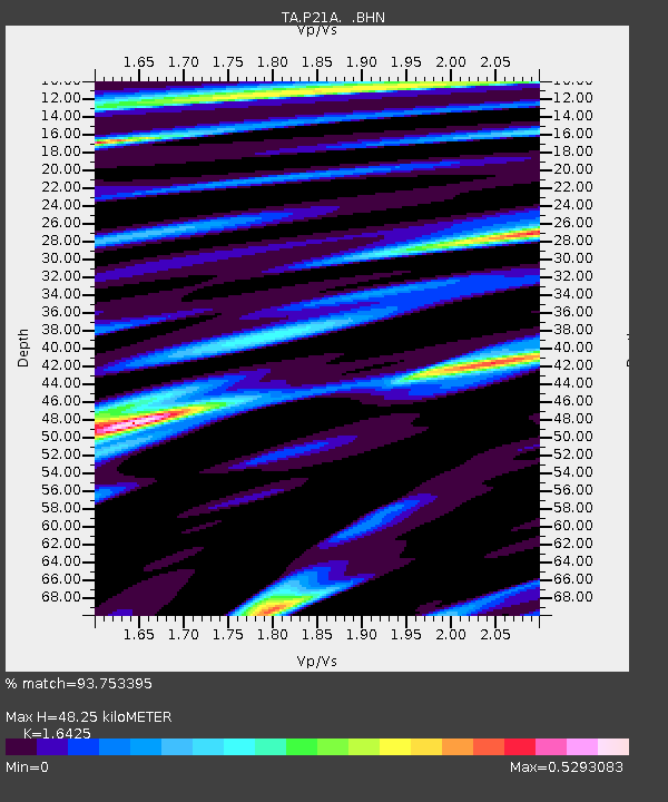
P21A Newcastle, CO, USA - Earthquake Result Viewer
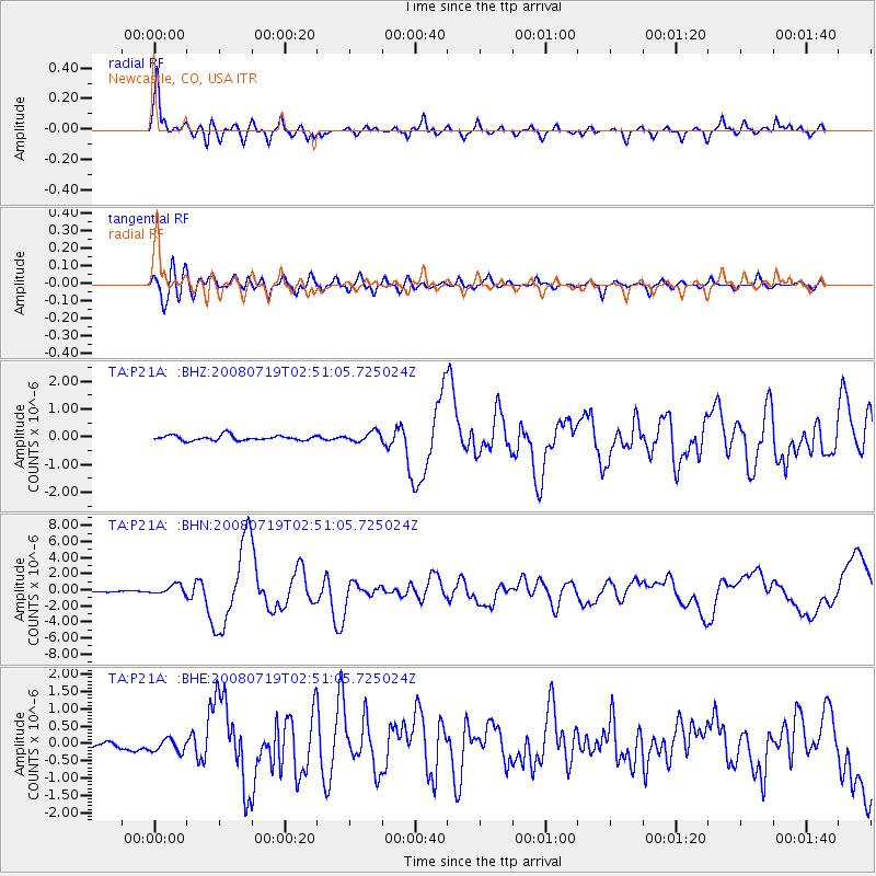
Earthquake location: Off East Coast Of Honshu, Japan
Earthquake latitude/longitude: 37.6/142.2
Earthquake time(UTC): 2008/07/19 (201) 02:39:28 GMT
Earthquake Depth: 22 km
Earthquake Magnitude: 6.2 MB, 7.0 MS, 7.0 MW, 6.9 MW
Earthquake Catalog/Contributor: WHDF/NEIC
Network: TA USArray Transportable Network (new EarthScope stations)
Station: P21A Newcastle, CO, USA
Lat/Lon: 39.52 N/107.45 W
Elevation: 2097 m
Distance: 80.2 deg
Az: 47.399 deg
Baz: 310.854 deg
Ray Param: 0.048450563
Estimated Moho Depth: 48.25 km
Estimated Crust Vp/Vs: 1.64
Assumed Crust Vp: 6.306 km/s
Estimated Crust Vs: 3.839 km/s
Estimated Crust Poisson's Ratio: 0.21
Radial Match: 93.753395 %
Radial Bump: 360
Transverse Match: 82.36508 %
Transverse Bump: 400
SOD ConfigId: 2504
Insert Time: 2010-03-06 02:21:13.618 +0000
GWidth: 2.5
Max Bumps: 400
Tol: 0.001

Signal To Noise

ChannelStoNSTALTA
TA:P21A: :BHN:20080719T02:51:05.725024Z7.4650186.025712E-78.071933E-8
TA:P21A: :BHE:20080719T02:51:05.725024Z1.65767841.8434292E-71.1120549E-7
TA:P21A: :BHZ:20080719T02:51:05.725024Z1.90734081.7717163E-79.2889344E-8
Arrivals
Ps5.1 SECOND
PpPs20 SECOND
PsPs/PpSs25 SECOND