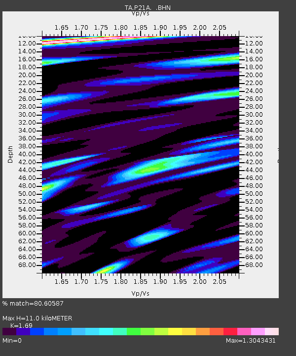
P21A Newcastle, CO, USA - Earthquake Result Viewer
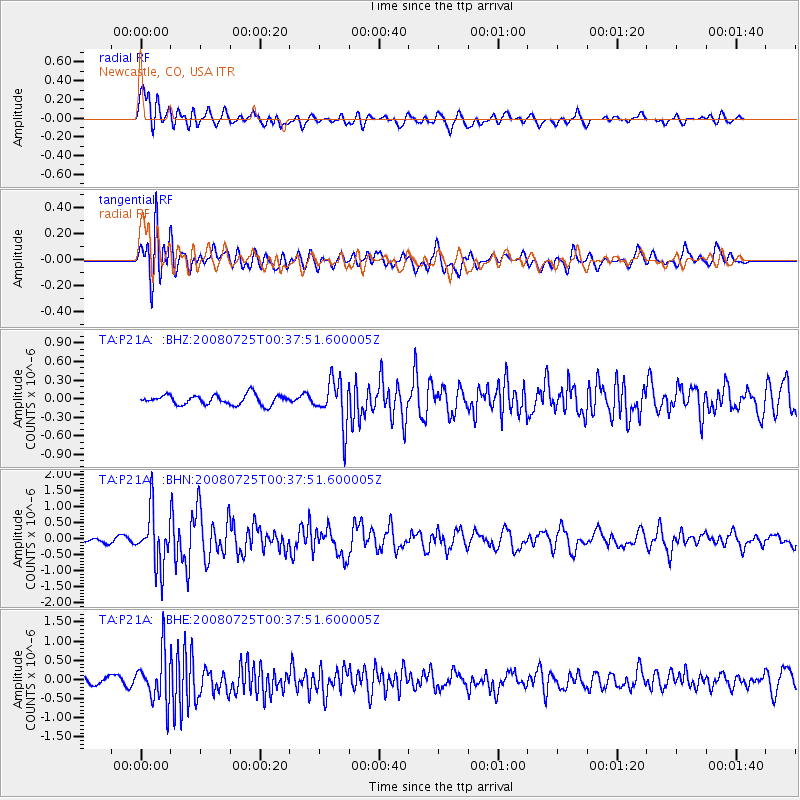
Earthquake location: Rat Islands, Aleutian Islands
Earthquake latitude/longitude: 51.3/179.0
Earthquake time(UTC): 2008/07/25 (207) 00:29:22 GMT
Earthquake Depth: 21 km
Earthquake Magnitude: 5.7 MB, 5.5 MS, 5.9 MW, 5.9 MW
Earthquake Catalog/Contributor: WHDF/NEIC
Network: TA USArray Transportable Network (new EarthScope stations)
Station: P21A Newcastle, CO, USA
Lat/Lon: 39.52 N/107.45 W
Elevation: 2097 m
Distance: 50.9 deg
Az: 72.925 deg
Baz: 309.08 deg
Ray Param: 0.067721896
Estimated Moho Depth: 11.0 km
Estimated Crust Vp/Vs: 1.69
Assumed Crust Vp: 6.306 km/s
Estimated Crust Vs: 3.731 km/s
Estimated Crust Poisson's Ratio: 0.23
Radial Match: 80.60587 %
Radial Bump: 400
Transverse Match: 64.565796 %
Transverse Bump: 400
SOD ConfigId: 2504
Insert Time: 2010-03-06 02:21:19.044 +0000
GWidth: 2.5
Max Bumps: 400
Tol: 0.001

Signal To Noise

ChannelStoNSTALTA
TA:P21A: :BHN:20080725T00:37:51.600005Z7.05853138.477521E-71.201032E-7
TA:P21A: :BHE:20080725T00:37:51.600005Z6.2336456.3270954E-71.01499126E-7
TA:P21A: :BHZ:20080725T00:37:51.600005Z4.5240783.5976453E-77.952218E-8
Arrivals
Ps1.3 SECOND
PpPs4.4 SECOND
PsPs/PpSs5.7 SECOND