You are here: Home > Network List > X812 - Deep Structure of Three Continental Sutures in Eastern North America Stations List
> Station COSY Clark's Harbour, Nova Scotia > Earthquake Result Viewer
COSY Clark's Harbour, Nova Scotia - Earthquake Result Viewer
| Earthquake location: |
North Atlantic Ocean |
| Earthquake latitude/longitude: |
13.4/-49.4 |
| Earthquake time(UTC): |
2017/07/27 (208) 17:53:25 GMT |
| Earthquake Depth: |
10 km |
| Earthquake Magnitude: |
5.9 Mww |
| Earthquake Catalog/Contributor: |
NEIC PDE/us |
|
| Network: |
X8 Deep Structure of Three Continental Sutures in Eastern North America |
| Station: |
COSY Clark's Harbour, Nova Scotia |
| Lat/Lon: |
43.44 N/65.63 W |
| Elevation: |
0.0 m |
|
| Distance: |
33.1 deg |
| Az: |
338.049 deg |
| Baz: |
150.038 deg |
| Ray Param: |
0.07838249 |
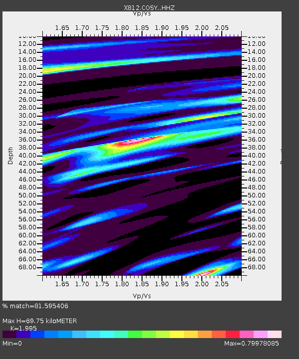
| Estimated Moho Depth: |
69.75 km |
| Estimated Crust Vp/Vs: |
2.00 |
| Assumed Crust Vp: |
6.134 km/s |
| Estimated Crust Vs: |
3.075 km/s |
| Estimated Crust Poisson's Ratio: |
0.33 |
|
| Radial Match: |
81.595406 % |
| Radial Bump: |
354 |
| Transverse Match: |
64.8762 % |
| Transverse Bump: |
400 |
| SOD ConfigId: |
13570011 |
| Insert Time: |
2019-04-28 11:46:50.291 +0000 |
| GWidth: |
2.5 |
| Max Bumps: |
400 |
| Tol: |
0.001 |
|

Signal To Noise
| Channel | StoN | STA | LTA |
| X8:COSY: :HHZ:20170727T17:59:29.520011Z | 2.0620883 | 3.1828358E-7 | 1.5435013E-7 |
| X8:COSY: :HHN:20170727T17:59:29.520011Z | 2.5235128 | 2.4189694E-7 | 9.585722E-8 |
| X8:COSY: :HHE:20170727T17:59:29.520011Z | 1.1414808 | 1.3183156E-7 | 1.15491694E-7 |
| Arrivals |
| Ps | 12 SECOND |
| PpPs | 32 SECOND |
| PsPs/PpSs | 44 SECOND |


