You are here: Home > Network List > TA - USArray Transportable Network (new EarthScope stations) Stations List
> Station P21A Newcastle, CO, USA > Earthquake Result Viewer
P21A Newcastle, CO, USA - Earthquake Result Viewer
| Earthquake location: |
Hokkaido, Japan Region |
| Earthquake latitude/longitude: |
41.8/143.4 |
| Earthquake time(UTC): |
2009/06/05 (156) 03:30:33 GMT |
| Earthquake Depth: |
29 km |
| Earthquake Magnitude: |
6.0 MB, 6.3 MS, 6.4 MW, 6.4 MW |
| Earthquake Catalog/Contributor: |
WHDF/NEIC |
|
| Network: |
TA USArray Transportable Network (new EarthScope stations) |
| Station: |
P21A Newcastle, CO, USA |
| Lat/Lon: |
39.52 N/107.45 W |
| Elevation: |
2097 m |
|
| Distance: |
76.6 deg |
| Az: |
48.705 deg |
| Baz: |
313.445 deg |
| Ray Param: |
0.050853085 |
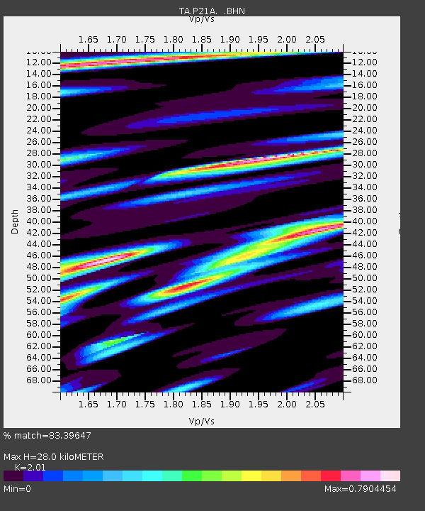
| Estimated Moho Depth: |
28.0 km |
| Estimated Crust Vp/Vs: |
2.01 |
| Assumed Crust Vp: |
6.306 km/s |
| Estimated Crust Vs: |
3.137 km/s |
| Estimated Crust Poisson's Ratio: |
0.34 |
|
| Radial Match: |
83.39647 % |
| Radial Bump: |
400 |
| Transverse Match: |
71.37857 % |
| Transverse Bump: |
400 |
| SOD ConfigId: |
2648 |
| Insert Time: |
2010-03-06 02:21:49.952 +0000 |
| GWidth: |
2.5 |
| Max Bumps: |
400 |
| Tol: |
0.001 |
|
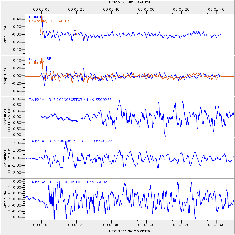
Signal To Noise
| Channel | StoN | STA | LTA |
| TA:P21A: :BHN:20090605T03:41:49.650027Z | 7.9179406 | 4.143865E-7 | 5.2335135E-8 |
| TA:P21A: :BHE:20090605T03:41:49.650027Z | 2.5366268 | 2.945592E-7 | 1.1612239E-7 |
| TA:P21A: :BHZ:20090605T03:41:49.650027Z | 2.1468635 | 2.0540465E-7 | 9.5676626E-8 |
| Arrivals |
| Ps | 4.6 SECOND |
| PpPs | 13 SECOND |
| PsPs/PpSs | 18 SECOND |


