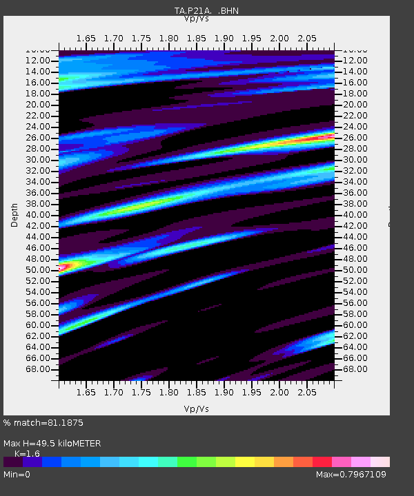
P21A Newcastle, CO, USA - Earthquake Result Viewer
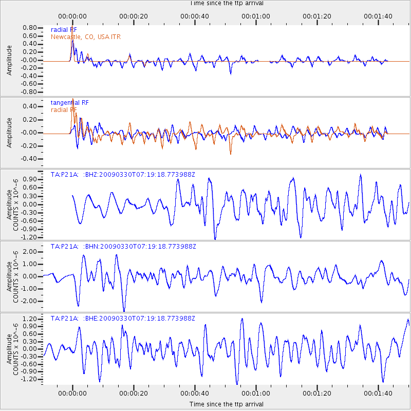
Earthquake location: Kodiak Island Region, Alaska
Earthquake latitude/longitude: 56.5/-152.7
Earthquake time(UTC): 2009/03/30 (089) 07:13:07 GMT
Earthquake Depth: 21 km
Earthquake Magnitude: 5.9 MB, 5.9 MS, 5.9 MW, 5.9 MW
Earthquake Catalog/Contributor: WHDF/NEIC
Network: TA USArray Transportable Network (new EarthScope stations)
Station: P21A Newcastle, CO, USA
Lat/Lon: 39.52 N/107.45 W
Elevation: 2097 m
Distance: 34.0 deg
Az: 100.509 deg
Baz: 315.246 deg
Ray Param: 0.07792862
Estimated Moho Depth: 49.5 km
Estimated Crust Vp/Vs: 1.60
Assumed Crust Vp: 6.306 km/s
Estimated Crust Vs: 3.941 km/s
Estimated Crust Poisson's Ratio: 0.18
Radial Match: 81.1875 %
Radial Bump: 397
Transverse Match: 59.724003 %
Transverse Bump: 400
SOD ConfigId: 2658
Insert Time: 2010-03-06 02:21:54.675 +0000
GWidth: 2.5
Max Bumps: 400
Tol: 0.001

Signal To Noise

ChannelStoNSTALTA
TA:P21A: :BHN:20090330T07:19:18.773988Z4.07963281.1805872E-62.8938564E-7
TA:P21A: :BHE:20090330T07:19:18.773988Z2.0424444.959022E-72.4279845E-7
TA:P21A: :BHZ:20090330T07:19:18.773988Z1.8817814.8650804E-72.5853595E-7
Arrivals
Ps5.1 SECOND
PpPs19 SECOND
PsPs/PpSs24 SECOND