You are here: Home > Network List > TA - USArray Transportable Network (new EarthScope stations) Stations List
> Station P21A Newcastle, CO, USA > Earthquake Result Viewer
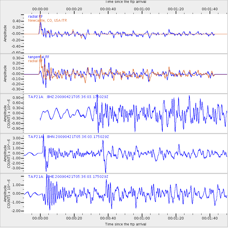
P21A Newcastle, CO, USA - Earthquake Result Viewer
*The percent match for this event was below the threshold and hence no stack was calculated.
| Earthquake location: |
Kuril Islands |
| Earthquake latitude/longitude: |
50.8/155.0 |
| Earthquake time(UTC): |
2009/04/21 (111) 05:26:11 GMT |
| Earthquake Depth: |
152 km |
| Earthquake Magnitude: |
6.0 MB, 6.2 MW, 6.2 MW |
| Earthquake Catalog/Contributor: |
WHDF/NEIC |
|
| Network: |
TA USArray Transportable Network (new EarthScope stations) |
| Station: |
P21A Newcastle, CO, USA |
| Lat/Lon: |
39.52 N/107.45 W |
| Elevation: |
2097 m |
|
| Distance: |
64.8 deg |
| Az: |
57.929 deg |
| Baz: |
315.992 deg |
| Ray Param: |
$rayparam |
*The percent match for this event was below the threshold and hence was not used in the summary stack. |
|
| Radial Match: |
76.7449 % |
| Radial Bump: |
400 |
| Transverse Match: |
64.85409 % |
| Transverse Bump: |
400 |
| SOD ConfigId: |
2760 |
| Insert Time: |
2010-03-06 02:22:04.011 +0000 |
| GWidth: |
2.5 |
| Max Bumps: |
400 |
| Tol: |
0.001 |
|
Signal To Noise
| Channel | StoN | STA | LTA |
| TA:P21A: :BHN:20090421T05:36:03.175029Z | 10.86911 | 1.6684559E-6 | 1.5350436E-7 |
| TA:P21A: :BHE:20090421T05:36:03.175029Z | 4.1186194 | 7.51671E-7 | 1.8250557E-7 |
| TA:P21A: :BHZ:20090421T05:36:03.175029Z | 2.7943285 | 4.8499436E-7 | 1.7356383E-7 |
| Arrivals |
| Ps | |
| PpPs | |
| PsPs/PpSs | |


