You are here: Home > Network List > TA - USArray Transportable Network (new EarthScope stations) Stations List
> Station P21A Newcastle, CO, USA > Earthquake Result Viewer
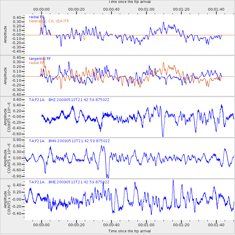
P21A Newcastle, CO, USA - Earthquake Result Viewer
*The percent match for this event was below the threshold and hence no stack was calculated.
| Earthquake location: |
Tonga Islands |
| Earthquake latitude/longitude: |
-15.8/-173.5 |
| Earthquake time(UTC): |
2009/05/13 (133) 21:31:17 GMT |
| Earthquake Depth: |
85 km |
| Earthquake Magnitude: |
5.8 MW, 5.3 MB, 5.8 MW |
| Earthquake Catalog/Contributor: |
WHDF/NEIC |
|
| Network: |
TA USArray Transportable Network (new EarthScope stations) |
| Station: |
P21A Newcastle, CO, USA |
| Lat/Lon: |
39.52 N/107.45 W |
| Elevation: |
2097 m |
|
| Distance: |
82.4 deg |
| Az: |
45.479 deg |
| Baz: |
242.581 deg |
| Ray Param: |
$rayparam |
*The percent match for this event was below the threshold and hence was not used in the summary stack. |
|
| Radial Match: |
51.99149 % |
| Radial Bump: |
400 |
| Transverse Match: |
61.11662 % |
| Transverse Bump: |
400 |
| SOD ConfigId: |
2760 |
| Insert Time: |
2010-03-06 02:22:06.455 +0000 |
| GWidth: |
2.5 |
| Max Bumps: |
400 |
| Tol: |
0.001 |
|
Signal To Noise
| Channel | StoN | STA | LTA |
| TA:P21A: :BHN:20090513T21:42:59.87502Z | 3.4656315 | 2.9440972E-7 | 8.4951246E-8 |
| TA:P21A: :BHE:20090513T21:42:59.87502Z | 0.7792405 | 9.072697E-8 | 1.1643E-7 |
| TA:P21A: :BHZ:20090513T21:42:59.87502Z | 1.730337 | 2.3229347E-7 | 1.3424753E-7 |
| Arrivals |
| Ps | |
| PpPs | |
| PsPs/PpSs | |


