You are here: Home > Network List > AV - Alaska Volcano Observatory Stations List
> Station AMKA Regional Station, Amchitka Island, Alaska > Earthquake Result Viewer
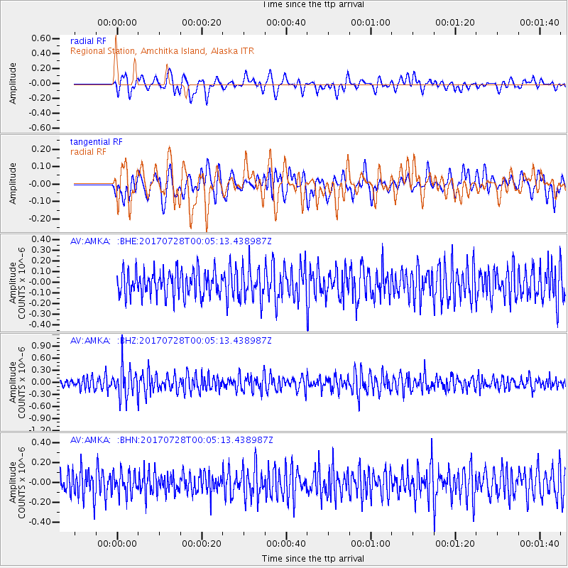
AMKA Regional Station, Amchitka Island, Alaska - Earthquake Result Viewer
*The percent match for this event was below the threshold and hence no stack was calculated.
| Earthquake location: |
Southeast Of Honshu, Japan |
| Earthquake latitude/longitude: |
29.3/143.0 |
| Earthquake time(UTC): |
2017/07/27 (208) 23:58:52 GMT |
| Earthquake Depth: |
10 km |
| Earthquake Magnitude: |
5.3 Mww |
| Earthquake Catalog/Contributor: |
NEIC PDE/us |
|
| Network: |
AV Alaska Volcano Observatory |
| Station: |
AMKA Regional Station, Amchitka Island, Alaska |
| Lat/Lon: |
51.38 N/179.30 E |
| Elevation: |
116 m |
|
| Distance: |
34.9 deg |
| Az: |
40.483 deg |
| Baz: |
244.823 deg |
| Ray Param: |
$rayparam |
*The percent match for this event was below the threshold and hence was not used in the summary stack. |
|
| Radial Match: |
58.10228 % |
| Radial Bump: |
400 |
| Transverse Match: |
46.631596 % |
| Transverse Bump: |
400 |
| SOD ConfigId: |
13570011 |
| Insert Time: |
2019-04-28 11:49:17.292 +0000 |
| GWidth: |
2.5 |
| Max Bumps: |
400 |
| Tol: |
0.001 |
|
Signal To Noise
| Channel | StoN | STA | LTA |
| AV:AMKA: :BHZ:20170728T00:05:13.438987Z | 3.1351392 | 3.841428E-7 | 1.2252814E-7 |
| AV:AMKA: :BHN:20170728T00:05:13.438987Z | 0.8439082 | 1.11315316E-7 | 1.3190453E-7 |
| AV:AMKA: :BHE:20170728T00:05:13.438987Z | 1.300075 | 1.4702005E-7 | 1.1308582E-7 |
| Arrivals |
| Ps | |
| PpPs | |
| PsPs/PpSs | |


