You are here: Home > Network List > TA - USArray Transportable Network (new EarthScope stations) Stations List
> Station P21A Newcastle, CO, USA > Earthquake Result Viewer
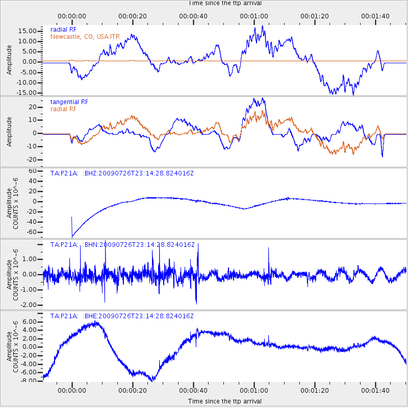
P21A Newcastle, CO, USA - Earthquake Result Viewer
*The percent match for this event was below the threshold and hence no stack was calculated.
| Earthquake location: |
Vanuatu Islands |
| Earthquake latitude/longitude: |
-17.8/168.1 |
| Earthquake time(UTC): |
2009/07/26 (207) 23:01:31 GMT |
| Earthquake Depth: |
25 km |
| Earthquake Magnitude: |
5.8 MB, 5.9 MW, 5.7 MW |
| Earthquake Catalog/Contributor: |
WHDF/NEIC |
|
| Network: |
TA USArray Transportable Network (new EarthScope stations) |
| Station: |
P21A Newcastle, CO, USA |
| Lat/Lon: |
39.52 N/107.45 W |
| Elevation: |
2097 m |
|
| Distance: |
96.9 deg |
| Az: |
50.854 deg |
| Baz: |
252.849 deg |
| Ray Param: |
$rayparam |
*The percent match for this event was below the threshold and hence was not used in the summary stack. |
|
| Radial Match: |
66.84965 % |
| Radial Bump: |
400 |
| Transverse Match: |
55.609707 % |
| Transverse Bump: |
400 |
| SOD ConfigId: |
2622 |
| Insert Time: |
2010-03-06 02:22:27.685 +0000 |
| GWidth: |
2.5 |
| Max Bumps: |
400 |
| Tol: |
0.001 |
|
Signal To Noise
| Channel | StoN | STA | LTA |
| TA:P21A: :BHN:20090726T23:14:28.824016Z | 1.4072857 | 4.0402657E-7 | 2.8709633E-7 |
| TA:P21A: :BHE:20090726T23:14:28.824016Z | 0.08075138 | 1.4540267E-6 | 1.8006214E-5 |
| TA:P21A: :BHZ:20090726T23:14:28.824016Z | 1.1494269 | 2.432455E-5 | 2.1162328E-5 |
| Arrivals |
| Ps | |
| PpPs | |
| PsPs/PpSs | |


