You are here: Home > Network List > TA - USArray Transportable Network (new EarthScope stations) Stations List
> Station P21A Newcastle, CO, USA > Earthquake Result Viewer
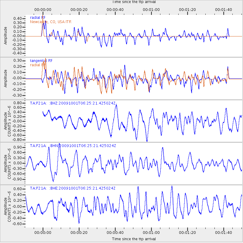
P21A Newcastle, CO, USA - Earthquake Result Viewer
*The percent match for this event was below the threshold and hence no stack was calculated.
| Earthquake location: |
Tonga Islands |
| Earthquake latitude/longitude: |
-15.4/-173.3 |
| Earthquake time(UTC): |
2009/10/01 (274) 06:13:32 GMT |
| Earthquake Depth: |
10 km |
| Earthquake Magnitude: |
5.6 MB, 5.7 MS, 5.8 MW, 5.7 MW |
| Earthquake Catalog/Contributor: |
WHDF/NEIC |
|
| Network: |
TA USArray Transportable Network (new EarthScope stations) |
| Station: |
P21A Newcastle, CO, USA |
| Lat/Lon: |
39.52 N/107.45 W |
| Elevation: |
2097 m |
|
| Distance: |
82.0 deg |
| Az: |
45.428 deg |
| Baz: |
242.678 deg |
| Ray Param: |
$rayparam |
*The percent match for this event was below the threshold and hence was not used in the summary stack. |
|
| Radial Match: |
51.050983 % |
| Radial Bump: |
400 |
| Transverse Match: |
64.60329 % |
| Transverse Bump: |
400 |
| SOD ConfigId: |
2622 |
| Insert Time: |
2010-03-06 02:22:42.177 +0000 |
| GWidth: |
2.5 |
| Max Bumps: |
400 |
| Tol: |
0.001 |
|
Signal To Noise
| Channel | StoN | STA | LTA |
| TA:P21A: :BHN:20091001T06:25:21.425024Z | 2.3538914 | 3.8128707E-7 | 1.6198159E-7 |
| TA:P21A: :BHE:20091001T06:25:21.425024Z | 1.0315888 | 2.0239635E-7 | 1.9619867E-7 |
| TA:P21A: :BHZ:20091001T06:25:21.425024Z | 1.0313917 | 2.0654848E-7 | 2.0026191E-7 |
| Arrivals |
| Ps | |
| PpPs | |
| PsPs/PpSs | |


