You are here: Home > Network List > TA - USArray Transportable Network (new EarthScope stations) Stations List
> Station P21A Newcastle, CO, USA > Earthquake Result Viewer
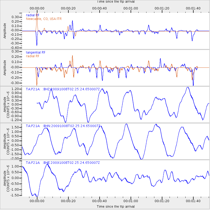
P21A Newcastle, CO, USA - Earthquake Result Viewer
*The percent match for this event was below the threshold and hence no stack was calculated.
| Earthquake location: |
Santa Cruz Islands |
| Earthquake latitude/longitude: |
-11.7/166.2 |
| Earthquake time(UTC): |
2009/10/08 (281) 02:12:39 GMT |
| Earthquake Depth: |
35 km |
| Earthquake Magnitude: |
5.8 MB, 6.6 MW |
| Earthquake Catalog/Contributor: |
WHDF/NEIC |
|
| Network: |
TA USArray Transportable Network (new EarthScope stations) |
| Station: |
P21A Newcastle, CO, USA |
| Lat/Lon: |
39.52 N/107.45 W |
| Elevation: |
2097 m |
|
| Distance: |
94.6 deg |
| Az: |
50.746 deg |
| Baz: |
258.743 deg |
| Ray Param: |
$rayparam |
*The percent match for this event was below the threshold and hence was not used in the summary stack. |
|
| Radial Match: |
67.08667 % |
| Radial Bump: |
346 |
| Transverse Match: |
49.335266 % |
| Transverse Bump: |
400 |
| SOD ConfigId: |
2622 |
| Insert Time: |
2010-03-06 02:22:48.871 +0000 |
| GWidth: |
2.5 |
| Max Bumps: |
400 |
| Tol: |
0.001 |
|
Signal To Noise
| Channel | StoN | STA | LTA |
| TA:P21A: :BHN:20091008T02:25:24.650007Z | 0.69311 | 9.086213E-7 | 1.3109337E-6 |
| TA:P21A: :BHE:20091008T02:25:24.650007Z | 1.2989681 | 1.2331598E-6 | 9.493381E-7 |
| TA:P21A: :BHZ:20091008T02:25:24.650007Z | 1.3764168 | 8.8226875E-7 | 6.409895E-7 |
| Arrivals |
| Ps | |
| PpPs | |
| PsPs/PpSs | |


