You are here: Home > Network List > TA - USArray Transportable Network (new EarthScope stations) Stations List
> Station P21A Newcastle, CO, USA > Earthquake Result Viewer
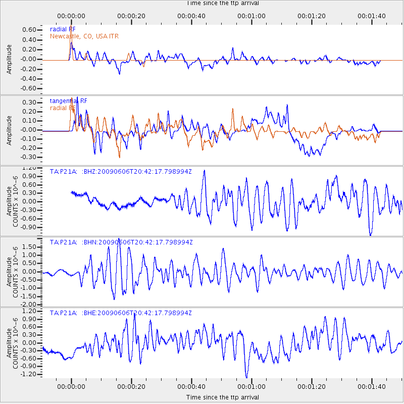
P21A Newcastle, CO, USA - Earthquake Result Viewer
*The percent match for this event was below the threshold and hence no stack was calculated.
| Earthquake location: |
Northern Mid-Atlantic Ridge |
| Earthquake latitude/longitude: |
23.9/-46.1 |
| Earthquake time(UTC): |
2009/06/06 (157) 20:33:28 GMT |
| Earthquake Depth: |
14 km |
| Earthquake Magnitude: |
6.0 MB, 5.7 MS, 6.0 MW, 6.0 MW |
| Earthquake Catalog/Contributor: |
WHDF/NEIC |
|
| Network: |
TA USArray Transportable Network (new EarthScope stations) |
| Station: |
P21A Newcastle, CO, USA |
| Lat/Lon: |
39.52 N/107.45 W |
| Elevation: |
2097 m |
|
| Distance: |
53.5 deg |
| Az: |
302.422 deg |
| Baz: |
87.657 deg |
| Ray Param: |
$rayparam |
*The percent match for this event was below the threshold and hence was not used in the summary stack. |
|
| Radial Match: |
62.2971 % |
| Radial Bump: |
400 |
| Transverse Match: |
48.096733 % |
| Transverse Bump: |
400 |
| SOD ConfigId: |
2648 |
| Insert Time: |
2010-03-06 02:22:58.696 +0000 |
| GWidth: |
2.5 |
| Max Bumps: |
400 |
| Tol: |
0.001 |
|
Signal To Noise
| Channel | StoN | STA | LTA |
| TA:P21A: :BHN:20090606T20:42:17.798994Z | 2.6022236 | 2.977882E-7 | 1.14436055E-7 |
| TA:P21A: :BHE:20090606T20:42:17.798994Z | 1.6656584 | 4.9000045E-7 | 2.9417822E-7 |
| TA:P21A: :BHZ:20090606T20:42:17.798994Z | 0.6905452 | 1.2105481E-7 | 1.7530324E-7 |
| Arrivals |
| Ps | |
| PpPs | |
| PsPs/PpSs | |


