You are here: Home > Network List > TA - USArray Transportable Network (new EarthScope stations) Stations List
> Station P21A Newcastle, CO, USA > Earthquake Result Viewer
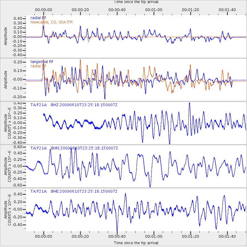
P21A Newcastle, CO, USA - Earthquake Result Viewer
*The percent match for this event was below the threshold and hence no stack was calculated.
| Earthquake location: |
West Chile Rise |
| Earthquake latitude/longitude: |
-41.7/-84.0 |
| Earthquake time(UTC): |
2009/06/10 (161) 23:13:21 GMT |
| Earthquake Depth: |
10 km |
| Earthquake Magnitude: |
5.7 MB, 5.2 MS, 5.7 MW, 5.6 MW |
| Earthquake Catalog/Contributor: |
WHDF/NEIC |
|
| Network: |
TA USArray Transportable Network (new EarthScope stations) |
| Station: |
P21A Newcastle, CO, USA |
| Lat/Lon: |
39.52 N/107.45 W |
| Elevation: |
2097 m |
|
| Distance: |
83.6 deg |
| Az: |
341.955 deg |
| Baz: |
162.552 deg |
| Ray Param: |
$rayparam |
*The percent match for this event was below the threshold and hence was not used in the summary stack. |
|
| Radial Match: |
58.6858 % |
| Radial Bump: |
400 |
| Transverse Match: |
48.916603 % |
| Transverse Bump: |
400 |
| SOD ConfigId: |
2648 |
| Insert Time: |
2010-03-06 02:23:01.268 +0000 |
| GWidth: |
2.5 |
| Max Bumps: |
400 |
| Tol: |
0.001 |
|
Signal To Noise
| Channel | StoN | STA | LTA |
| TA:P21A: :BHN:20090610T23:25:18.150007Z | 4.1498656 | 2.4478555E-7 | 5.8986377E-8 |
| TA:P21A: :BHE:20090610T23:25:18.150007Z | 1.2148395 | 1.1076358E-7 | 9.117549E-8 |
| TA:P21A: :BHZ:20090610T23:25:18.150007Z | 1.137619 | 8.2134356E-8 | 7.2198475E-8 |
| Arrivals |
| Ps | |
| PpPs | |
| PsPs/PpSs | |


