You are here: Home > Network List > TA - USArray Transportable Network (new EarthScope stations) Stations List
> Station D23K Nanushuk River, AK USA > Earthquake Result Viewer
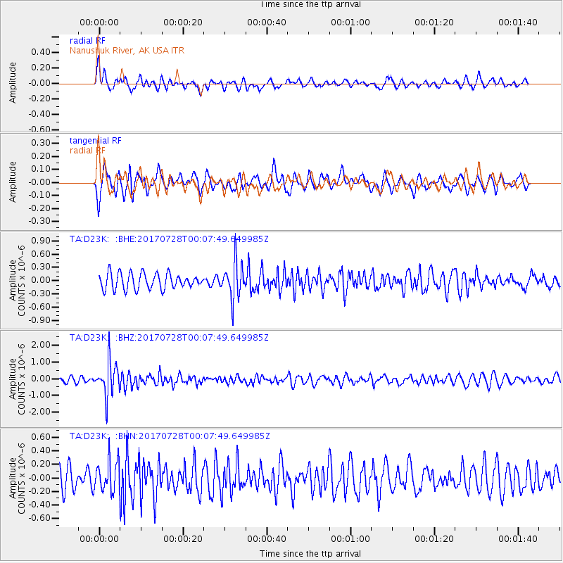
D23K Nanushuk River, AK USA - Earthquake Result Viewer
*The percent match for this event was below the threshold and hence no stack was calculated.
| Earthquake location: |
Southeast Of Honshu, Japan |
| Earthquake latitude/longitude: |
29.3/143.0 |
| Earthquake time(UTC): |
2017/07/27 (208) 23:58:52 GMT |
| Earthquake Depth: |
10 km |
| Earthquake Magnitude: |
5.3 Mww |
| Earthquake Catalog/Contributor: |
NEIC PDE/us |
|
| Network: |
TA USArray Transportable Network (new EarthScope stations) |
| Station: |
D23K Nanushuk River, AK USA |
| Lat/Lon: |
68.97 N/150.68 W |
| Elevation: |
406 m |
|
| Distance: |
54.5 deg |
| Az: |
23.959 deg |
| Baz: |
259.316 deg |
| Ray Param: |
$rayparam |
*The percent match for this event was below the threshold and hence was not used in the summary stack. |
|
| Radial Match: |
61.083157 % |
| Radial Bump: |
400 |
| Transverse Match: |
56.352722 % |
| Transverse Bump: |
400 |
| SOD ConfigId: |
13570011 |
| Insert Time: |
2019-04-28 11:55:09.698 +0000 |
| GWidth: |
2.5 |
| Max Bumps: |
400 |
| Tol: |
0.001 |
|
Signal To Noise
| Channel | StoN | STA | LTA |
| TA:D23K: :BHZ:20170728T00:07:49.649985Z | 6.113829 | 1.0209059E-6 | 1.6698307E-7 |
| TA:D23K: :BHN:20170728T00:07:49.649985Z | 1.5667951 | 2.3374498E-7 | 1.4918669E-7 |
| TA:D23K: :BHE:20170728T00:07:49.649985Z | 2.332181 | 4.090816E-7 | 1.7540731E-7 |
| Arrivals |
| Ps | |
| PpPs | |
| PsPs/PpSs | |


