You are here: Home > Network List > TA - USArray Transportable Network (new EarthScope stations) Stations List
> Station P21A Newcastle, CO, USA > Earthquake Result Viewer
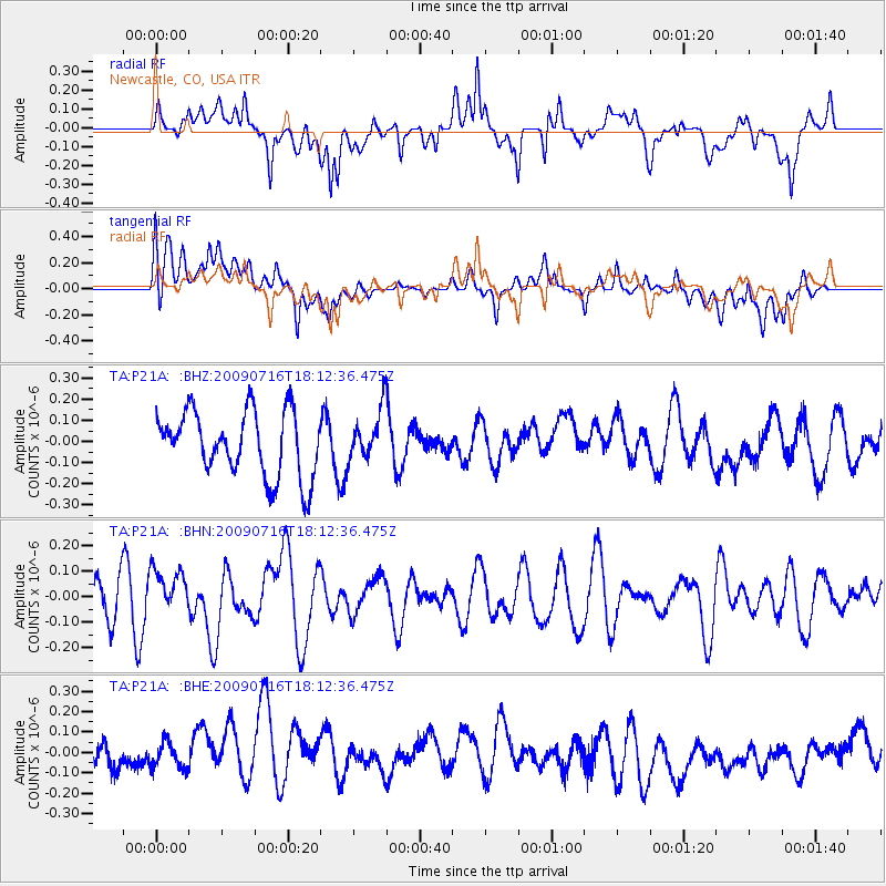
P21A Newcastle, CO, USA - Earthquake Result Viewer
*The percent match for this event was below the threshold and hence no stack was calculated.
| Earthquake location: |
Vanuatu Islands |
| Earthquake latitude/longitude: |
-17.5/167.7 |
| Earthquake time(UTC): |
2009/07/16 (197) 17:59:36 GMT |
| Earthquake Depth: |
10 km |
| Earthquake Magnitude: |
5.8 MW, 5.4 MS, 5.4 MB, 5.8 MW |
| Earthquake Catalog/Contributor: |
WHDF/NEIC |
|
| Network: |
TA USArray Transportable Network (new EarthScope stations) |
| Station: |
P21A Newcastle, CO, USA |
| Lat/Lon: |
39.52 N/107.45 W |
| Elevation: |
2097 m |
|
| Distance: |
97.1 deg |
| Az: |
50.916 deg |
| Baz: |
253.244 deg |
| Ray Param: |
$rayparam |
*The percent match for this event was below the threshold and hence was not used in the summary stack. |
|
| Radial Match: |
49.17236 % |
| Radial Bump: |
400 |
| Transverse Match: |
36.70912 % |
| Transverse Bump: |
400 |
| SOD ConfigId: |
2648 |
| Insert Time: |
2010-03-06 02:23:14.596 +0000 |
| GWidth: |
2.5 |
| Max Bumps: |
400 |
| Tol: |
0.001 |
|
Signal To Noise
| Channel | StoN | STA | LTA |
| TA:P21A: :BHN:20090716T18:12:36.475Z | 1.2349567 | 8.5516E-8 | 6.924615E-8 |
| TA:P21A: :BHE:20090716T18:12:36.475Z | 0.6915775 | 8.686039E-8 | 1.2559748E-7 |
| TA:P21A: :BHZ:20090716T18:12:36.475Z | 0.77484053 | 1.1832917E-7 | 1.5271422E-7 |
| Arrivals |
| Ps | |
| PpPs | |
| PsPs/PpSs | |


