You are here: Home > Network List > TA - USArray Transportable Network (new EarthScope stations) Stations List
> Station I30M Mount Dempster, Yukon, CAN > Earthquake Result Viewer
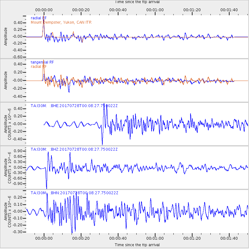
I30M Mount Dempster, Yukon, CAN - Earthquake Result Viewer
*The percent match for this event was below the threshold and hence no stack was calculated.
| Earthquake location: |
Southeast Of Honshu, Japan |
| Earthquake latitude/longitude: |
29.3/143.0 |
| Earthquake time(UTC): |
2017/07/27 (208) 23:58:52 GMT |
| Earthquake Depth: |
10 km |
| Earthquake Magnitude: |
5.3 Mww |
| Earthquake Catalog/Contributor: |
NEIC PDE/us |
|
| Network: |
TA USArray Transportable Network (new EarthScope stations) |
| Station: |
I30M Mount Dempster, Yukon, CAN |
| Lat/Lon: |
65.22 N/136.38 W |
| Elevation: |
1399 m |
|
| Distance: |
59.9 deg |
| Az: |
28.717 deg |
| Baz: |
275.075 deg |
| Ray Param: |
$rayparam |
*The percent match for this event was below the threshold and hence was not used in the summary stack. |
|
| Radial Match: |
74.38096 % |
| Radial Bump: |
400 |
| Transverse Match: |
72.23022 % |
| Transverse Bump: |
400 |
| SOD ConfigId: |
13570011 |
| Insert Time: |
2019-04-28 11:55:51.195 +0000 |
| GWidth: |
2.5 |
| Max Bumps: |
400 |
| Tol: |
0.001 |
|
Signal To Noise
| Channel | StoN | STA | LTA |
| TA:I30M: :BHZ:20170728T00:08:27.750022Z | 7.8029194 | 4.4335448E-7 | 5.681905E-8 |
| TA:I30M: :BHN:20170728T00:08:27.750022Z | 2.7770596 | 9.5937445E-8 | 3.4546414E-8 |
| TA:I30M: :BHE:20170728T00:08:27.750022Z | 5.4772205 | 2.5011812E-7 | 4.5665153E-8 |
| Arrivals |
| Ps | |
| PpPs | |
| PsPs/PpSs | |


