You are here: Home > Network List > TA - USArray Transportable Network (new EarthScope stations) Stations List
> Station P21A Newcastle, CO, USA > Earthquake Result Viewer
P21A Newcastle, CO, USA - Earthquake Result Viewer
*The percent match for this event was below the threshold and hence no stack was calculated.
| Earthquake location: |
Loyalty Islands |
| Earthquake latitude/longitude: |
-20.2/168.9 |
| Earthquake time(UTC): |
2008/04/09 (100) 11:23:40 GMT |
| Earthquake Depth: |
35 km |
| Earthquake Magnitude: |
5.7 MB, 6.3 MW, 6.3 MW |
| Earthquake Catalog/Contributor: |
WHDF/NEIC |
|
| Network: |
TA USArray Transportable Network (new EarthScope stations) |
| Station: |
P21A Newcastle, CO, USA |
| Lat/Lon: |
39.52 N/107.45 W |
| Elevation: |
2097 m |
|
| Distance: |
97.9 deg |
| Az: |
50.897 deg |
| Baz: |
250.467 deg |
| Ray Param: |
$rayparam |
*The percent match for this event was below the threshold and hence was not used in the summary stack. |
|
| Radial Match: |
55.751564 % |
| Radial Bump: |
319 |
| Transverse Match: |
46.110603 % |
| Transverse Bump: |
400 |
| SOD ConfigId: |
2504 |
| Insert Time: |
2010-03-06 02:23:18.536 +0000 |
| GWidth: |
2.5 |
| Max Bumps: |
400 |
| Tol: |
0.001 |
|
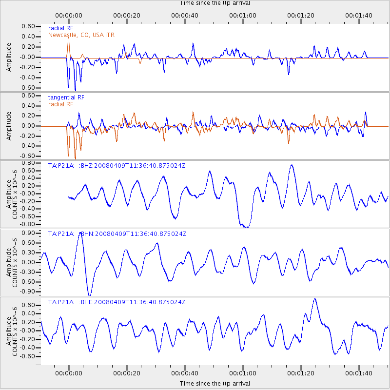
Signal To Noise
| Channel | StoN | STA | LTA |
| TA:P21A: :BHN:20080409T11:36:40.875024Z | 2.0595822 | 5.319716E-7 | 2.5829104E-7 |
| TA:P21A: :BHE:20080409T11:36:40.875024Z | 0.8773128 | 1.5366092E-7 | 1.7514952E-7 |
| TA:P21A: :BHZ:20080409T11:36:40.875024Z | 1.4532124 | 2.605765E-7 | 1.7931069E-7 |
| Arrivals |
| Ps | |
| PpPs | |
| PsPs/PpSs | |


