You are here: Home > Network List > CI - Caltech Regional Seismic Network Stations List
> Station CHF Chilao Flat Rngr Sta, Altadena, CA, USA > Earthquake Result Viewer
CHF Chilao Flat Rngr Sta, Altadena, CA, USA - Earthquake Result Viewer
| Earthquake location: |
Kodiak Island Region, Alaska |
| Earthquake latitude/longitude: |
57.1/-153.2 |
| Earthquake time(UTC): |
2001/01/10 (010) 16:02:44 GMT |
| Earthquake Depth: |
33 km |
| Earthquake Magnitude: |
6.2 MB, 6.8 MS, 7.1 MW, 6.8 ML |
| Earthquake Catalog/Contributor: |
WHDF/NEIC |
|
| Network: |
CI Caltech Regional Seismic Network |
| Station: |
CHF Chilao Flat Rngr Sta, Altadena, CA, USA |
| Lat/Lon: |
34.33 N/118.03 W |
| Elevation: |
1594 m |
|
| Distance: |
32.9 deg |
| Az: |
118.603 deg |
| Baz: |
324.595 deg |
| Ray Param: |
0.07840421 |
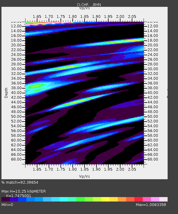
| Estimated Moho Depth: |
10.25 km |
| Estimated Crust Vp/Vs: |
1.75 |
| Assumed Crust Vp: |
6.1 km/s |
| Estimated Crust Vs: |
3.491 km/s |
| Estimated Crust Poisson's Ratio: |
0.26 |
|
| Radial Match: |
92.39654 % |
| Radial Bump: |
284 |
| Transverse Match: |
83.81561 % |
| Transverse Bump: |
400 |
| SOD ConfigId: |
3787 |
| Insert Time: |
2010-02-26 01:22:07.027 +0000 |
| GWidth: |
2.5 |
| Max Bumps: |
400 |
| Tol: |
0.001 |
|
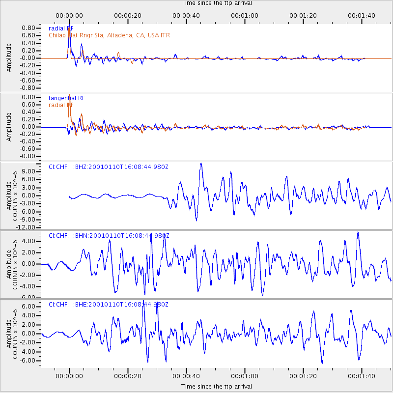
Signal To Noise
| Channel | StoN | STA | LTA |
| CI:CHF: :BHN:20010110T16:08:44.980Z | 2.6034577 | 1.1056702E-6 | 4.2469298E-7 |
| CI:CHF: :BHE:20010110T16:08:44.980Z | 1.2865181 | 6.7820434E-7 | 5.271627E-7 |
| CI:CHF: :BHZ:20010110T16:08:44.980Z | 3.3138497 | 1.6579617E-6 | 5.003129E-7 |
| Arrivals |
| Ps | 1.3 SECOND |
| PpPs | 4.3 SECOND |
| PsPs/PpSs | 5.6 SECOND |


