You are here: Home > Network List > TA - USArray Transportable Network (new EarthScope stations) Stations List
> Station MSTX Muleshoe, TX, USA > Earthquake Result Viewer
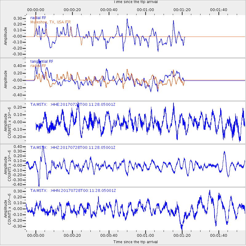
MSTX Muleshoe, TX, USA - Earthquake Result Viewer
*The percent match for this event was below the threshold and hence no stack was calculated.
| Earthquake location: |
Southeast Of Honshu, Japan |
| Earthquake latitude/longitude: |
29.3/143.0 |
| Earthquake time(UTC): |
2017/07/27 (208) 23:58:52 GMT |
| Earthquake Depth: |
10 km |
| Earthquake Magnitude: |
5.3 Mww |
| Earthquake Catalog/Contributor: |
NEIC PDE/us |
|
| Network: |
TA USArray Transportable Network (new EarthScope stations) |
| Station: |
MSTX Muleshoe, TX, USA |
| Lat/Lon: |
33.97 N/102.77 W |
| Elevation: |
1167 m |
|
| Distance: |
91.6 deg |
| Az: |
49.28 deg |
| Baz: |
307.181 deg |
| Ray Param: |
$rayparam |
*The percent match for this event was below the threshold and hence was not used in the summary stack. |
|
| Radial Match: |
53.57651 % |
| Radial Bump: |
400 |
| Transverse Match: |
48.50131 % |
| Transverse Bump: |
400 |
| SOD ConfigId: |
13570011 |
| Insert Time: |
2019-04-28 11:56:24.305 +0000 |
| GWidth: |
2.5 |
| Max Bumps: |
400 |
| Tol: |
0.001 |
|
Signal To Noise
| Channel | StoN | STA | LTA |
| TA:MSTX: :HHZ:20170728T00:11:28.05001Z | 3.6843083 | 2.3294689E-7 | 6.3226764E-8 |
| TA:MSTX: :HHN:20170728T00:11:28.05001Z | 0.9042477 | 6.232617E-8 | 6.892599E-8 |
| TA:MSTX: :HHE:20170728T00:11:28.05001Z | 0.6610731 | 6.404812E-8 | 9.688509E-8 |
| Arrivals |
| Ps | |
| PpPs | |
| PsPs/PpSs | |


