You are here: Home > Network List > TA - USArray Transportable Network (new EarthScope stations) Stations List
> Station I25A Rochford, SD, USA > Earthquake Result Viewer
I25A Rochford, SD, USA - Earthquake Result Viewer
| Earthquake location: |
Santa Cruz Islands |
| Earthquake latitude/longitude: |
-11.6/166.1 |
| Earthquake time(UTC): |
2009/08/10 (222) 04:06:31 GMT |
| Earthquake Depth: |
35 km |
| Earthquake Magnitude: |
5.8 MB, 6.3 MS, 6.6 MW, 6.6 MW |
| Earthquake Catalog/Contributor: |
WHDF/NEIC |
|
| Network: |
TA USArray Transportable Network (new EarthScope stations) |
| Station: |
I25A Rochford, SD, USA |
| Lat/Lon: |
44.02 N/103.73 W |
| Elevation: |
1856 m |
|
| Distance: |
98.1 deg |
| Az: |
46.775 deg |
| Baz: |
261.744 deg |
| Ray Param: |
0.039994363 |
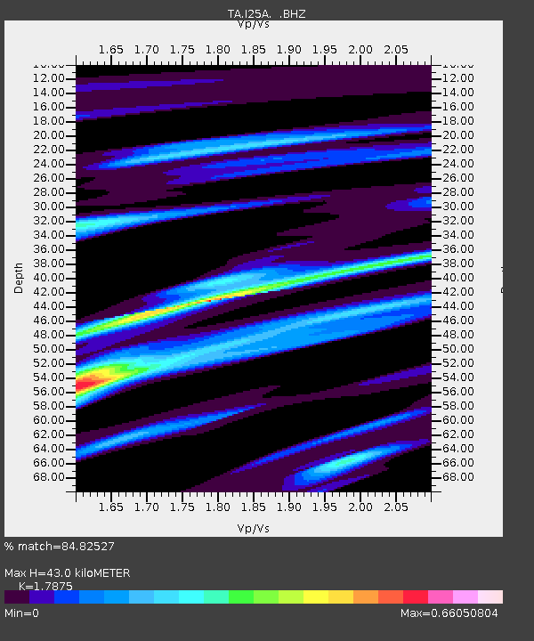
| Estimated Moho Depth: |
43.0 km |
| Estimated Crust Vp/Vs: |
1.79 |
| Assumed Crust Vp: |
6.242 km/s |
| Estimated Crust Vs: |
3.492 km/s |
| Estimated Crust Poisson's Ratio: |
0.27 |
|
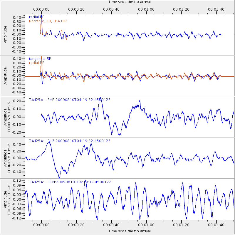
| Radial Match: |
84.82527 % |
| Radial Bump: |
400 |
| Transverse Match: |
52.711605 % |
| Transverse Bump: |
400 |
| SOD ConfigId: |
2622 |
| Insert Time: |
2010-03-06 02:23:35.662 +0000 |
| GWidth: |
2.5 |
| Max Bumps: |
400 |
| Tol: |
0.001 |
|
Signal To Noise
| Channel | StoN | STA | LTA |
| TA:I25A: :BHZ:20090810T04:19:32.450012Z | 5.858369 | 3.1429488E-7 | 5.3648872E-8 |
| TA:I25A: :BHN:20090810T04:19:32.450012Z | 0.8050456 | 3.422819E-8 | 4.2517083E-8 |
| TA:I25A: :BHE:20090810T04:19:32.450012Z | 4.9610295 | 1.5072496E-7 | 3.038179E-8 |
| Arrivals |
| Ps | 5.5 SECOND |
| PpPs | 19 SECOND |
| PsPs/PpSs | 24 SECOND |


